Difference between revisions of "2010-08-17 41 -81"
From Geohashing
imported>Jschleappi (page created, twmplate needed) |
m |
||
| (12 intermediate revisions by 4 users not shown) | |||
| Line 1: | Line 1: | ||
| − | + | <!-- If you did not specify these parameters in the template, please substitute appropriate things for IMAGE, LAT, LON, and DATE (YYYY-MM-DD format) | |
| − | |||
| − | == the | + | {{subst:Expedition|lat=##|lon=##|date=YYYY-MM-DD}} |
| − | + | ||
| + | [[Image:{{{image|IMAGE}}}|thumb|left]] | ||
| + | |||
| + | Remove this section if you don't want a image at the top (left) of your report. You should remove the "Image:" or "File:" | ||
| + | tag from your image file name, and replace the all upper-case word IMAGE in the above line. | ||
| + | |||
| + | And DON'T FORGET to add your expedition and the best photo you took to the gallery on the Main Page! We'd love to read your report, but that means we first have to discover it! | ||
| + | --> | ||
| + | {{meetup graticule | ||
| + | | lat=41 | ||
| + | | lon=-81 | ||
| + | | date=2010-08-17 | ||
| + | }} | ||
| + | |||
| + | |||
| + | __NOTOC__ | ||
| + | |||
| + | == Location == | ||
| + | |||
| + | The official hash is in someone's backyard, so an alternate meet up location has been found to the east in Roadside Park. A trek shall be made to as close to the hash as we can get once everyone has arrived. | ||
| + | |||
| + | == Participants == | ||
| + | <!-- who attended --> | ||
| + | * [[User:jschleappi|jSchleappi]] | ||
| + | * Many Someone elses? | ||
| + | |||
| + | == Plans == | ||
| + | It's [[User:jschleappi|jSchleappi]]'s birthday today, so cupcakes shall be brought and Frisbee shall be played! | ||
| + | |||
| + | == Expedition == | ||
| + | <!-- how it all turned out. your narrative goes here. --> | ||
| + | |||
| + | == Tracklog == | ||
| + | <!-- if your GPS device keeps a log, you may post a link here --> | ||
| + | |||
| + | == Photos == | ||
| + | <!-- Insert pictures between the gallery tags using the following format: | ||
| + | Image:2010-##-## ## ## Alpha.jpg | Witty Comment | ||
| + | --> | ||
| + | <gallery perrow="5"> | ||
| + | |||
| + | Image:2010-08-17_41_-81_17-46-40-403.jpg | Picnic and birthday geohash! [http://www.openstreetmap.org/?lat=41.565756&lon=-81.4350845&zoom=16&layers=B000FTF @41.5658,-81.4351] | ||
| + | |||
| + | Image:2010-08-17_41_-81_18-16-32-861.jpg | Here Aw are! [http://www.openstreetmap.org/?lat=41.5619&lon=-81.4504&zoom=16&layers=B000FTF @41.5619,-81.4504] | ||
| + | |||
| + | Image:2010-08-17_41_-81_18-59-58-292.jpg | Cupcakes! | ||
| + | </gallery> | ||
| + | |||
| + | == Achievements == | ||
| + | {{#vardefine:ribbonwidth|800px}} | ||
| + | <!-- Add any achievement ribbons you earned below, or remove this section --> | ||
| + | |||
| + | |||
| + | [[Category:Expeditions]] | ||
| + | |||
| + | [[Category:Expeditions with photos]] | ||
| + | [[Category:Coordinates not reached]] | ||
| + | [[Category:Not reached - No public access]] | ||
| + | |||
| + | <!-- if you reached your coords: | ||
| + | [[Category:Coordinates reached]] | ||
| + | --> | ||
| + | |||
| + | <!-- or if you failed :( | ||
| + | [[Category:Coordinates not reached]] | ||
| + | -- and a reason -- | ||
| + | [[Category:Not reached - Mother Nature]] | ||
| + | [[Category:Not reached - No public access]] | ||
| + | [[Category:Not reached - Technology]] | ||
| + | [[Category:Not reached - Did not attempt]] | ||
| + | --> | ||
| + | {{location|US|OH|CU}} | ||
Latest revision as of 09:14, 24 April 2022
| Tue 17 Aug 2010 in 41,-81: 41.5622128, -81.4502247 geohashing.info google osm bing/os kml crox |
Location
The official hash is in someone's backyard, so an alternate meet up location has been found to the east in Roadside Park. A trek shall be made to as close to the hash as we can get once everyone has arrived.
Participants
- jSchleappi
- Many Someone elses?
Plans
It's jSchleappi's birthday today, so cupcakes shall be brought and Frisbee shall be played!
Expedition
Tracklog
Photos
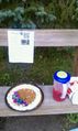
Picnic and birthday geohash! @41.5658,-81.4351
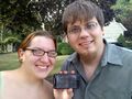
Here Aw are! @41.5619,-81.4504
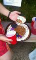
Cupcakes!


