Difference between revisions of "2010-09-30 55 13"
imported>Fasanen (→Plans) |
imported>Fasanen (→Expedition) |
||
| Line 17: | Line 17: | ||
== Expedition == | == Expedition == | ||
| + | Today's hash was in our neighbourhood (only 14 kilometers away) so we decided to make a slight detour on our way to the lovely Häckeberga forest where Ms.C was going to exercise her bicycling skills. Google maps indicated a field in Hemmeryd on top of the Romelåsen ridge. I estimated a fifty-fifty chance of reaching the coordinates. Reason for failure would be growing crops. | ||
| + | At nine o’clock the car was loaded with bikes and apples. After a nice car trip we got 20 meters from the hash. To our disappointment the field was newly sown so we had to accept a [[No_Trespassing_Geohash|"No trespassing consolation prize"]]. | ||
| + | |||
| + | This was my first “failed” expedition. | ||
== Photos == | == Photos == | ||
Revision as of 13:02, 30 September 2010
| Thu 30 Sep 2010 in 55,13: 55.5552664, 13.5530041 geohashing.info google osm bing/os kml crox |
Location
Field in Hemmeryd.
Participants
Fasanen & Ms.C
Plans
Make a slight detour and short stop on our way to the Häckeberga forest.
Expedition
Today's hash was in our neighbourhood (only 14 kilometers away) so we decided to make a slight detour on our way to the lovely Häckeberga forest where Ms.C was going to exercise her bicycling skills. Google maps indicated a field in Hemmeryd on top of the Romelåsen ridge. I estimated a fifty-fifty chance of reaching the coordinates. Reason for failure would be growing crops.
At nine o’clock the car was loaded with bikes and apples. After a nice car trip we got 20 meters from the hash. To our disappointment the field was newly sown so we had to accept a "No trespassing consolation prize".
This was my first “failed” expedition.
Photos
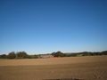
Hash is 20 meters in the direction of the barn
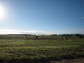
View south
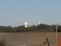
Romele radar towers seen from hash-20 meters
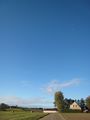
View west


