Difference between revisions of "2010-09-30 55 13"
imported>Fasanen (Created page with '{{meetup graticule | lat=55 | lon=13 | date=2010-09-30 }} __NOTOC__ == Location == Hemmeryd == Participants == Fasanen & Ms.C == Plans == == Expedition == …') |
imported>FippeBot m (Location) |
||
| (9 intermediate revisions by one other user not shown) | |||
| Line 8: | Line 8: | ||
__NOTOC__ | __NOTOC__ | ||
== Location == | == Location == | ||
| − | Hemmeryd | + | Field in Hemmeryd. |
== Participants == | == Participants == | ||
| Line 14: | Line 14: | ||
== Plans == | == Plans == | ||
| + | Make a slight detour and short stop on our way to the Häckeberga forest. | ||
== Expedition == | == Expedition == | ||
| + | Today's hash (interesting coordinates BTW) was in our neighbourhood (only 14 kilometers away) so we decided to make a slight detour on our way to the lovely Häckeberga forest where Ms.C was going to exercise her bicycling skills. Google maps indicated a field in Hemmeryd on top of the Romelåsen ridge. I estimated a fifty-fifty chance of reaching the coordinates. Reason for failure would be growing crops. | ||
| + | At nine o’clock the car was loaded with bikes and apples. After a nice car trip we got 20 meters from the hash. To our disappointment the field was newly sown so we had to accept a [[No_Trespassing_Geohash|"No trespassing consolation prize"]]. | ||
| + | |||
| + | This was my first “failed” expedition. | ||
== Photos == | == Photos == | ||
<gallery perrow=4"> | <gallery perrow=4"> | ||
| − | Image:551320100930 | + | Image:551320100930 1.JPG | Hash is 20 meters in the direction of the barn |
| − | Image:551320100930 | + | Image:551320100930 2.JPG | View south with sun |
| − | Image:551320100930 | + | Image:551320100930 3.JPG | Romele radar towers seen from hash+20 meters |
| − | Image:551320100930 | + | Image:551320100930 4.JPG | View west with moon |
</gallery> | </gallery> | ||
| + | |||
| + | == Achievements == | ||
| + | {{No trespassing | ||
| + | | latitude = 55 | ||
| + | | longitude = 13 | ||
| + | | date = 2010-09-30 | ||
| + | | name = [[User:Fasanen|Fasanen]] | ||
| + | |||
| + | }} | ||
[[Category:Expeditions]] | [[Category:Expeditions]] | ||
[[Category:Expeditions with photos]] | [[Category:Expeditions with photos]] | ||
| + | [[Category:Coordinates not reached]] | ||
[[Category:Not reached - No public access]] | [[Category:Not reached - No public access]] | ||
| + | {{location|SE|M}} | ||
Latest revision as of 03:56, 9 August 2019
| Thu 30 Sep 2010 in 55,13: 55.5552664, 13.5530041 geohashing.info google osm bing/os kml crox |
Location
Field in Hemmeryd.
Participants
Fasanen & Ms.C
Plans
Make a slight detour and short stop on our way to the Häckeberga forest.
Expedition
Today's hash (interesting coordinates BTW) was in our neighbourhood (only 14 kilometers away) so we decided to make a slight detour on our way to the lovely Häckeberga forest where Ms.C was going to exercise her bicycling skills. Google maps indicated a field in Hemmeryd on top of the Romelåsen ridge. I estimated a fifty-fifty chance of reaching the coordinates. Reason for failure would be growing crops.
At nine o’clock the car was loaded with bikes and apples. After a nice car trip we got 20 meters from the hash. To our disappointment the field was newly sown so we had to accept a "No trespassing consolation prize".
This was my first “failed” expedition.
Photos
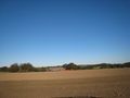
Hash is 20 meters in the direction of the barn
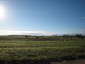
View south with sun
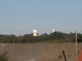
Romele radar towers seen from hash+20 meters
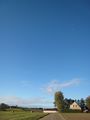
View west with moon


Achievements
Fasanen earned the No trespassing consolation prize
|