Difference between revisions of "2010-10-03 66 25"
From Geohashing
imported>Isopekka |
imported>Isopekka |
||
| Line 46: | Line 46: | ||
<Gallery> | <Gallery> | ||
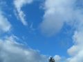
| + | Image:Gh9.jpg| From the road downhill and then across the marsh. No, we do not have snow yet! | ||
Image:Gd2+gh9 007.JPG| 800 m to the point. Maybe there are birds to hunt on the way... | Image:Gd2+gh9 007.JPG| 800 m to the point. Maybe there are birds to hunt on the way... | ||
Image:Gd2+gh9 008.JPG| 200 m to the Hash, right across the wet marsh. | Image:Gd2+gh9 008.JPG| 200 m to the Hash, right across the wet marsh. | ||
Revision as of 14:58, 3 October 2010
| Sun 3 Oct 2010 in 66,25: 66.8362717, 25.6914929 geohashing.info google osm bing/os kml crox |
Location
About 40 km N from Rovaniemi, 10 km E from the village Patokoski, Finland. Point is in the wilderness.
Participants
- isopekka & Tintti & dog
Expedition
I reached the hashpoint at 02:00 p.m.
- Walking total 1.6 km
- By car total about 100 km
- Expedition took 3 hours
- Physical efforts needed (1-5): 3
Photos
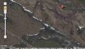
From the road downhill and then across the marsh. No, we do not have snow yet!
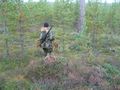
800 m to the point. Maybe there are birds to hunt on the way...
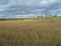
200 m to the Hash, right across the wet marsh.
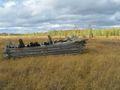
70 m to the Hash from this ex-building.
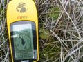
At the Hashpoint.
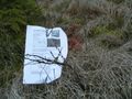
Hashpoint marked.
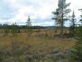
View to NW from the Hash.
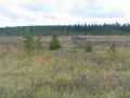
View to SW from the Hash.
Above the Hash.


