Difference between revisions of "2010-11-05 40 -74"
From Geohashing
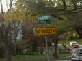
imported>Jevanyn ([retro picture] Corner of Banner and Colburn [http://www.openstreetmap.org/?lat=40.4714&lon=-74.4144&zoom=16&layers=B000FTF @40.4714,-74.4144]) |
imported>Jevanyn ([retro picture] Looking, er, north on Colburn. A resident walking her dogs. [http://www.openstreetmap.org/?lat=40.4714&lon=-74.4144&zoom=16&layers=B000FTF @40.4714,-74.4144]) |
||
| Line 43: | Line 43: | ||
Image:2010-11-05_40_-74_17-13-15-819.jpg | Corner of Banner and Colburn [http://www.openstreetmap.org/?lat=40.4714&lon=-74.4144&zoom=16&layers=B000FTF @40.4714,-74.4144] | Image:2010-11-05_40_-74_17-13-15-819.jpg | Corner of Banner and Colburn [http://www.openstreetmap.org/?lat=40.4714&lon=-74.4144&zoom=16&layers=B000FTF @40.4714,-74.4144] | ||
| + | |||
| + | Image:2010-11-05_40_-74_17-14-09-134.jpg | Looking, er, north on Colburn. A resident walking her dogs. [http://www.openstreetmap.org/?lat=40.4714&lon=-74.4144&zoom=16&layers=B000FTF @40.4714,-74.4144] | ||
</gallery> | </gallery> | ||
Revision as of 21:14, 6 November 2010
| Fri 5 Nov 2010 in 40,-74: 40.4714409, -74.4144591 geohashing.info google osm bing/os kml crox |
Location
Participants
Plans
Expedition
- On the way back from the 2010-11-06 geohash, I stopped in E. Brunswick for the geohash from the day before. -- Jevanyn @40.4716,-74.4145 17:09, 06 November 2010 (EDT)
Tracklog
Photos

Evan, standing right at the hashpoint @40.4714,-74.4144
Corner of Banner and Colburn @40.4714,-74.4144

Looking, er, north on Colburn. A resident walking her dogs. @40.4714,-74.4144


Achievements