Difference between revisions of "2010-11-05 40 -74"
imported>Jevanyn ([retro] On the way back from the 2010-11-06 geohash, I stopped in E. Brunswick for the geohash from the day before.) |
imported>FippeBot m (Location) |
||
| (10 intermediate revisions by 3 users not shown) | |||
| Line 1: | Line 1: | ||
| − | |||
| − | |||
| − | |||
| − | |||
| − | |||
| − | |||
| − | |||
| − | |||
| − | |||
| − | |||
{{meetup graticule | {{meetup graticule | ||
| lat=40 | | lat=40 | ||
| lon=-74 | | lon=-74 | ||
| date=2010-11-05 | | date=2010-11-05 | ||
| + | | retro=1 | ||
}} | }} | ||
| − | + | ||
__NOTOC__ | __NOTOC__ | ||
== Location == | == Location == | ||
| − | + | Sidewalk of Colburn St. in East Brunswick, New Jersey. The neighborhood is tucked in between NJ-18 and a lake, on the far side of which lies the Cook-Douglass campus of Rutgers University. | |
== Participants == | == Participants == | ||
| − | + | [[User:Jevanyn|Jevanyn]] and Evan | |
== Plans == | == Plans == | ||
| − | + | After reaching the [[2010-11-06 40 -74|November 6 geohash]], I decided to stop here on the way back. | |
== Expedition == | == Expedition == | ||
| − | + | On the way back from the 2010-11-06 geohash, I stopped in E. Brunswick for the geohash from the day before. -- [[User:Jevanyn|Jevanyn]] [http://www.openstreetmap.org/?lat=40.47155437&lon=-74.41447817&zoom=16&layers=B000FTF @40.4716,-74.4145] 17:09, 06 November 2010 (EDT) | |
| + | I put my trust in Sprint Navigation to give us decent directions there from Middletown. It succeeded in directing us, but showed a preference for toll roads (Parkway and Turnpike). I was on the Parkway before I could avoid it, but ignored the turn for the Turnpike, knowing the US-1 was a simpler route with no tolls. SprintNav recalculated the route in plenty of time to direct me onto US-1 (which I was going to do anyway). | ||
| − | + | == Achievements == | |
| − | == | + | {{gratuitous ribbon |
| − | + | |latitude=40 | |
| + | |longitude=-74 | ||
| + | |date=2010-11-06 | ||
| + | |name=[[User:Jevanyn|Jevanyn]] | ||
| + | |achievement=Multihash achievement (variant) | ||
| + | |description=reaching the previous day's geohash on the same expedition as reaching the | ||
| + | |icon=Minesweeper geohash 2.png | ||
| + | }} | ||
== Photos == | == Photos == | ||
| − | + | Again, Geohash Droid app made posting pictures easy. | |
| − | |||
| − | |||
<gallery perrow="5"> | <gallery perrow="5"> | ||
| − | |||
| − | == | + | Image:2010-11-05_40_-74_17-12-24-795.jpg | Evan, standing right at the hashpoint [http://www.openstreetmap.org/?lat=40.4714&lon=-74.4144&zoom=16&layers=B000FTF @40.4714,-74.4144] |
| − | |||
| − | |||
| + | Image:2010-11-05_40_-74_17-13-15-819.jpg | Corner of Banner and Colburn [http://www.openstreetmap.org/?lat=40.4714&lon=-74.4144&zoom=16&layers=B000FTF @40.4714,-74.4144] | ||
| − | + | Image:2010-11-05_40_-74_17-14-09-134.jpg | Looking, er, north on Colburn. A resident walking her dogs. [http://www.openstreetmap.org/?lat=40.4714&lon=-74.4144&zoom=16&layers=B000FTF @40.4714,-74.4144] | |
| − | |||
| − | |||
| − | + | Image:2010-11-05_40_-74_17-14-56-865.jpg | Looking south on Colburn. [http://www.openstreetmap.org/?lat=40.4714&lon=-74.4144&zoom=16&layers=B000FTF @40.4714,-74.4144] | |
| − | + | </gallery> | |
| − | [ | ||
| − | |||
| − | |||
| − | |||
| − | |||
[[Category:Expeditions with photos]] | [[Category:Expeditions with photos]] | ||
| − | [[Category: | + | [[Category:Retro coordinates reached]] |
| − | + | [[Category:Jevanyn/brought Evan]] | |
| − | + | {{location|US|NJ|MI}} | |
| − | |||
| − | |||
| − | |||
| − | |||
| − | |||
| − | |||
| − | [[Category: | ||
| − | |||
| − | |||
| − | |||
| − | |||
| − | |||
| − | |||
Latest revision as of 04:30, 9 August 2019
| Fri 5 Nov 2010 in 40,-74: 40.4714409, -74.4144591 geohashing.info google osm bing/os kml crox |
Location
Sidewalk of Colburn St. in East Brunswick, New Jersey. The neighborhood is tucked in between NJ-18 and a lake, on the far side of which lies the Cook-Douglass campus of Rutgers University.
Participants
Jevanyn and Evan
Plans
After reaching the November 6 geohash, I decided to stop here on the way back.
Expedition
On the way back from the 2010-11-06 geohash, I stopped in E. Brunswick for the geohash from the day before. -- Jevanyn @40.4716,-74.4145 17:09, 06 November 2010 (EDT)
I put my trust in Sprint Navigation to give us decent directions there from Middletown. It succeeded in directing us, but showed a preference for toll roads (Parkway and Turnpike). I was on the Parkway before I could avoid it, but ignored the turn for the Turnpike, knowing the US-1 was a simpler route with no tolls. SprintNav recalculated the route in plenty of time to direct me onto US-1 (which I was going to do anyway).
Achievements
Jevanyn earned the Multihash achievement (variant)
|
Photos
Again, Geohash Droid app made posting pictures easy.
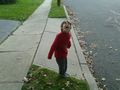
Evan, standing right at the hashpoint @40.4714,-74.4144
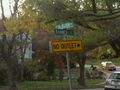
Corner of Banner and Colburn @40.4714,-74.4144
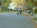
Looking, er, north on Colburn. A resident walking her dogs. @40.4714,-74.4144
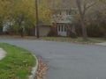
Looking south on Colburn. @40.4714,-74.4144


