Difference between revisions of "2010-12-26 55 13"
imported>Llavids |
imported>FippeBot m (Location) |
||
| (5 intermediate revisions by 2 users not shown) | |||
| Line 10: | Line 10: | ||
== Participants == | == Participants == | ||
| − | * [[User: | + | * [[User:Llavids|Llavids]] |
== Plans == | == Plans == | ||
| − | The | + | The geohash was near a place I had visited as 12-year old schoolboy on a school day out. I |
| + | was interested to see if I remembered the place correctly and hoped it would be easier to reach | ||
| + | the geohash through the woods. | ||
== Expedition == | == Expedition == | ||
| − | I had to park behind Bjärsjölagård, about 450 meters from the road leading into the woods. It was easy | + | I had to park behind Bjärsjölagård, about 450 meters from the road leading into the woods. It was easy walking on the road to the woods. |
| + | When entering the woods on a smaller road somebody else had been there before with skiis and a dog. | ||
| + | I and our dog walked in the old ski marks down to the limestone quarry. I had never returned here | ||
| + | since I was 12 but it looked much like what I had remembered. I found out there was a geocache | ||
| + | nearby so I went for it. Unfortunately my digging in the snow didn't help. I couldn't find it. | ||
| + | The geohash was about 500 meters south of the quarry, and I had to get over or around the quarry. | ||
| + | When walking in the woods I found out that the snow was too deep. It poured down inside my | ||
| + | wellingtons and the dog had to jump over the snow for every step forward. | ||
| + | |||
| + | Since the clock was about 12.30 and we had guests coming to our house at 14.00 I calculated that reaching | ||
| + | the geohash and returning was going to take me at up to 2 hours, I called it a day and | ||
| + | returned home and could greet my guests at 14.00 instead. | ||
== Photos == | == Photos == | ||
| − | <gallery perrow=" | + | <gallery perrow="4"> |
Image:101226-01-Limestone-quarry.JPG|Limestone quarry | Image:101226-01-Limestone-quarry.JPG|Limestone quarry | ||
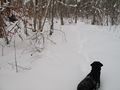
Image:101226-02-Enough.JPG|Enough is enough, remembered to take a photo on my way back | Image:101226-02-Enough.JPG|Enough is enough, remembered to take a photo on my way back | ||
| Line 26: | Line 39: | ||
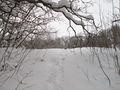
Image:101226-04-Go-home.JPG|Going home | Image:101226-04-Go-home.JPG|Going home | ||
Image:101226-05-Bjärsjölagård.JPG|Bjärsjölagård | Image:101226-05-Bjärsjölagård.JPG|Bjärsjölagård | ||
| − | Image:101226-06-Limestone-kiln.JPG|Limestone kiln behind Bjärsjölagård close to parking | + | Image:101226-06-Limestone-kiln.JPG|Limestone kiln behind Bjärsjölagård close to parking (they are called Adam and Eve) |
</gallery> | </gallery> | ||
| − | |||
[[Category:Expeditions]] | [[Category:Expeditions]] | ||
[[Category:Expeditions with photos]] | [[Category:Expeditions with photos]] | ||
| − | [[Category:Coordinates not reached]] | + | [[Category:Coordinates not reached]][[Category:Not reached - Time constraints]] |
[[Category:Sweden]] | [[Category:Sweden]] | ||
| + | {{location|SE|M}} | ||
Latest revision as of 05:03, 9 August 2019
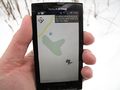
| Sun 26 Dec 2010 in 55,13: 55.7216583, 13.7087315 geohashing.info google osm bing/os kml crox |
Location
Near Bjärsjölagård, outside Hörby, Skåne, Sweden.
Participants
Plans
The geohash was near a place I had visited as 12-year old schoolboy on a school day out. I was interested to see if I remembered the place correctly and hoped it would be easier to reach the geohash through the woods.
Expedition
I had to park behind Bjärsjölagård, about 450 meters from the road leading into the woods. It was easy walking on the road to the woods. When entering the woods on a smaller road somebody else had been there before with skiis and a dog. I and our dog walked in the old ski marks down to the limestone quarry. I had never returned here since I was 12 but it looked much like what I had remembered. I found out there was a geocache nearby so I went for it. Unfortunately my digging in the snow didn't help. I couldn't find it. The geohash was about 500 meters south of the quarry, and I had to get over or around the quarry. When walking in the woods I found out that the snow was too deep. It poured down inside my wellingtons and the dog had to jump over the snow for every step forward.
Since the clock was about 12.30 and we had guests coming to our house at 14.00 I calculated that reaching the geohash and returning was going to take me at up to 2 hours, I called it a day and returned home and could greet my guests at 14.00 instead.
Photos
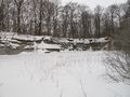
Limestone quarry
Enough is enough, remembered to take a photo on my way back
More and more snow
Going home
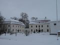
Bjärsjölagård
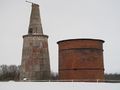
Limestone kiln behind Bjärsjölagård close to parking (they are called Adam and Eve)


