Difference between revisions of "2011-01-06 1 103"
imported>Cyazlars |
imported>Cyazlars |
||
| Line 17: | Line 17: | ||
__NOTOC__ | __NOTOC__ | ||
== Location == | == Location == | ||
| − | + | Parking lot opposite the Singapore Indoor Stadium, under the second tree on the fourth row. | |
== Participants == | == Participants == | ||
| − | + | [[User:Cyazlars|Cyazlars]] | |
| + | |||
| + | Jaz | ||
| + | |||
| + | Gracia | ||
== Plans == | == Plans == | ||
| − | + | I wasn't very serious about visiting the geohash, but just in case I changed my mind I did do some research on how to get there and I noted down the landmarks around the geohash. Grabbed my camera as I packed for school - didn't want to be caught with no proper camera if I finally decided I'd go! I didn't print out a map at home because I figured I could have it printed more clearly at school. | |
== Expedition == | == Expedition == | ||
| − | |||
| − | + | ''"Human memory is a marvelous but fallacious instrument." - Primo Levi'' | |
| − | + | ||
| + | As it turned out, in my hurry to meet my friends Jaz, Gracia and BQ for lunch I had completely forgotten to print out the map. No problem, I had seen the map before and I was pretty sure I could make my way there without much trouble at all using only what I had remembered. I was very certain of the geohash's position in my head - '''first''' tree, on either the '''second''' or the '''third''' row. It couldn't possibly be the fourth or the fifth, or any further than that - in my mind it was too far. Later I tried using both my phone as well as Jaz's to confirm, but neither of them could use Satellite View in Google Maps. Still, I was rather confident that my memory was at least accurate to some degree. | ||
| − | + | After lunch I was still undecided about visiting the geohash - it was getting rather late and I did feel rather full. And would I feel comfortable making my way there alone? I asked my friends for advice, which turned into me explaining to Gracia what geohashing was all about, and to my pleasant surprise she was rather excited about the concept and wanted to tag along. Jaz didn't mind either, and we all needed a walk after lunch. We finally set off at around 5pm from Orchard MRT (after ducking into several shops along the way and spending some time in them). BQ did not join us and went home instead. Jaz, Gracia and I alighted at Stadium MRT to walk towards the geohash. | |
| − | |||
| − | |||
| − | |||
| − | |||
| − | |||
| − | + | We spotted a 7-Eleven at the MRT station and I thought it would be a good opportunity for a geoSquishy, but alas! It was closed. We continued walking towards the carpark, which was very empty when we got there. Which was good, because what we were doing would look very weird to others. I couldn't remember whether it was the tree in the second or third row that the geohash was at, so I decided we would take 'victory shots' at both trees and then check the map again later when I got home. | |
| − | |||
| − | |||
| + | I felt pretty good about the whole geohash expedition - coordinates reached, even a drag-along! Something I never thought I'd be able to convince people about! Now it was just a matter of getting home, looking at the map to confirm our position, and then...''oh''. | ||
| − | + | '''Second''' tree. '''Fourth''' row. 32m away from our closest point. | |
| − | |||
| − | |||
| − | <!-- | + | == Photos == |
| − | < | + | <gallery perrow="4"> |
| − | + | Image:2011-01-06_1_103_Friends.jpg | Jaz and Gracia | |
| − | --> | + | Image:2011-01-06_1_103_7-Eleven.jpg | Potential GeoSquishy! |
| + | Image:2011-01-06_1_103_WHAT.jpg | What the- 5pm?! | ||
| + | Image:2011-01-06_1_103_Singapore_Indoor_Stadium.jpg | Landmark No. 1: Singapore Indoor Stadium | ||
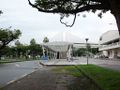
| + | Image:2011-01-06_1_103_Kallang_Theatre.jpg | Landmark No. 2: Kallang Theatre | ||
| + | Image:2011-01-06_1_103_Overhead_Bridge.jpg | Landmark No. 3: Overhead bridge | ||
| + | Image:2011-01-06_1_103_Carpark.jpg | Geohash location | ||
| + | Image:2011-01-06_1_103_1-2_Tree.jpg | Second row, first tree | ||
| + | Image:2011-01-06_1_103_Time.jpg | Time verification | ||
| + | Image:2011-01-06_1_103_1-3_Tree.jpg | Third row, first tree (and in the background, to your right...the ''real'' geohash) | ||
| + | Image:2011-01-06_1_103_Walkway.jpg | Walkway beside the carpark, before the first row | ||
| + | Image:2011-01-06_1_103_Kallang_Leisure_Park.jpg | Thought we'd drop by | ||
| + | Image:2011-01-06_1_103_LOOK.jpg | LOOK IT'S OPEN AND IT'S <1KM AWAY. | ||
| + | Image:2011-01-06_1_103_Squishy.jpg | Unfortunately it didn't qualify as a GeoSquishy in the end... | ||
| + | Image:2011-01-06_1_103_Enjoying.jpg | ...but it tasted good anyway. | ||
| + | Image:2011-01-06_1_103_End.jpg | Better luck next time, then. | ||
| + | </gallery> | ||
| − | |||
[[Category:Expeditions]] | [[Category:Expeditions]] | ||
| − | |||
[[Category:Expeditions with photos]] | [[Category:Expeditions with photos]] | ||
| − | |||
[[Category:Expedition without GPS]] | [[Category:Expedition without GPS]] | ||
| − | |||
| − | |||
| − | |||
| − | |||
| − | |||
| − | |||
[[Category:Coordinates not reached]] | [[Category:Coordinates not reached]] | ||
| − | |||
| − | |||
| − | |||
| − | |||
| − | |||
| − | |||
Revision as of 18:06, 6 January 2011
| Thu 6 Jan 2011 in 1,103: 1.3009364, 103.8760756 geohashing.info google osm bing/os kml crox |
Location
Parking lot opposite the Singapore Indoor Stadium, under the second tree on the fourth row.
Participants
Jaz
Gracia
Plans
I wasn't very serious about visiting the geohash, but just in case I changed my mind I did do some research on how to get there and I noted down the landmarks around the geohash. Grabbed my camera as I packed for school - didn't want to be caught with no proper camera if I finally decided I'd go! I didn't print out a map at home because I figured I could have it printed more clearly at school.
Expedition
"Human memory is a marvelous but fallacious instrument." - Primo Levi
As it turned out, in my hurry to meet my friends Jaz, Gracia and BQ for lunch I had completely forgotten to print out the map. No problem, I had seen the map before and I was pretty sure I could make my way there without much trouble at all using only what I had remembered. I was very certain of the geohash's position in my head - first tree, on either the second or the third row. It couldn't possibly be the fourth or the fifth, or any further than that - in my mind it was too far. Later I tried using both my phone as well as Jaz's to confirm, but neither of them could use Satellite View in Google Maps. Still, I was rather confident that my memory was at least accurate to some degree.
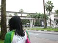
After lunch I was still undecided about visiting the geohash - it was getting rather late and I did feel rather full. And would I feel comfortable making my way there alone? I asked my friends for advice, which turned into me explaining to Gracia what geohashing was all about, and to my pleasant surprise she was rather excited about the concept and wanted to tag along. Jaz didn't mind either, and we all needed a walk after lunch. We finally set off at around 5pm from Orchard MRT (after ducking into several shops along the way and spending some time in them). BQ did not join us and went home instead. Jaz, Gracia and I alighted at Stadium MRT to walk towards the geohash.
We spotted a 7-Eleven at the MRT station and I thought it would be a good opportunity for a geoSquishy, but alas! It was closed. We continued walking towards the carpark, which was very empty when we got there. Which was good, because what we were doing would look very weird to others. I couldn't remember whether it was the tree in the second or third row that the geohash was at, so I decided we would take 'victory shots' at both trees and then check the map again later when I got home.
I felt pretty good about the whole geohash expedition - coordinates reached, even a drag-along! Something I never thought I'd be able to convince people about! Now it was just a matter of getting home, looking at the map to confirm our position, and then...oh.
Second tree. Fourth row. 32m away from our closest point.
Photos
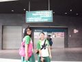
Jaz and Gracia

Potential GeoSquishy!
What the- 5pm?!
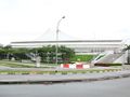
Landmark No. 1: Singapore Indoor Stadium

Landmark No. 2: Kallang Theatre
Landmark No. 3: Overhead bridge
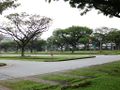
Geohash location

Second row, first tree

Time verification

Third row, first tree (and in the background, to your right...the real geohash)
Walkway beside the carpark, before the first row

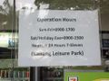
Thought we'd drop by

LOOK IT'S OPEN AND IT'S <1KM AWAY.

Unfortunately it didn't qualify as a GeoSquishy in the end...

...but it tasted good anyway.

Better luck next time, then.


