Difference between revisions of "2011-01-18 48 11"
imported>Mayzoon (→Plans) |
imported>Mayzoon (→Tracklog) |
||
| Line 32: | Line 32: | ||
That was a successful beginner's geohash. | That was a successful beginner's geohash. | ||
| − | |||
| − | |||
| − | |||
== Photos == | == Photos == | ||
Revision as of 19:15, 18 January 2011
| Tue 18 Jan 2011 in 48,11: 48.0904497, 11.6215995 geohashing.info google osm bing/os kml crox |
Location
On a muddy field in the south of munich.
Participants
Expedition
I looked up some upcoming coordinates a few days ago, then I was surprised that those today are really accessible! So I packed some useful items together and took my bike to get to the spot. I followed a muddy path and then I finally was about 40 meters away. I put my bike aside and went straight on towards the coordinates. Every step it got harder to walk, I even thought about sinking in this swamp. Then I took some photos, made a screenshot of my GPS and placed a neatly carved stick in the recent plought field. I put my email adress on it, maybe I'll get some kind of virtual "message in a bottle". Finally I reached the path again and tried to clean my footwear... Well, I tried it at least.
When I came home, I told my dad of this expedition, because he noticed my dirty shoes. He didn't say anything but grinned...
That was a successful beginner's geohash.
Photos
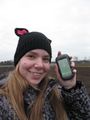
me at my first geohash
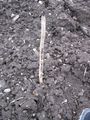
the mark I left
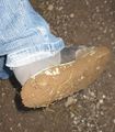
my shoes..
Yep, I was there.


Achievements