Difference between revisions of "2011-01-31 45 -91"
imported>Tom10animal (Created page with "This WILL happen today. Unemployment rocks.") |
imported>FippeBot m (Location) |
||
| (36 intermediate revisions by 3 users not shown) | |||
| Line 1: | Line 1: | ||
| − | This WILL happen today. | + | [[Image:2011_01_31_45_-91_ACCESS_DENIED.png|thumb|left]] |
| + | |||
| + | {{meetup graticule | ||
| + | | lat=45 | ||
| + | | lon=-91 | ||
| + | | date=2011-01-31 | ||
| + | }} | ||
| + | |||
| + | __NOTOC__ | ||
| + | == Location == | ||
| + | The hash is on a ridge located on private property a few miles west of Bloomer, WI. | ||
| + | |||
| + | == Participants == | ||
| + | [[User:tom10animal|Tom Schäffer]] | ||
| + | |||
| + | == Plans == | ||
| + | 0338 CST - This WILL happen today, unless the location is on private property. | ||
| + | |||
| + | 0830 CST, The location is on private property in a farmer's field west of Bloomer. [[User:tom10animal|Tom Schäffer]] will attempt to ask permission, but it looks like he will be racking up a No Trespassing achievement for the day and travelling to the closest possible spot, the point on Highway A due south of the location. | ||
| + | |||
| + | == Expedition == | ||
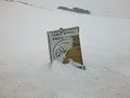
| + | I left my apartment in Ridgeland at 0913 and, after cleaning snow off the car, was under-way. The roads were snow-covered and slippery, so I had to keep it under 45 the whole trip. Snow was falling the entire time. By the time I reached CTH A, I realized that I didn't have my camera, and would be forced to use my Droid to take pictures documenting the area surrounding the hash. Nobody was home at the closest residence, so I only stayed a few minutes taking some pictures of some interesting signs in the area, including a No Trespassing sign, and the ridge over which the hash lay. Since I couldn't photograph the coordinates, I have a picture of a distinctive intersection around the "block" (where I'd actually probably start hiking from to reach the hash had I had permission to proceed). Figuring it was time to get out of the road and make room for the township's plow, I headed down to Menomonie to take care of some errands. Overall, a fun jump into Geohashing (despite not being able to deflower the graticule). Looks like the first official expedition of the graticule ends up earning a No Trespassing Geohash achievement. | ||
| + | |||
| + | == Photos == | ||
| + | <gallery perrow="5"> | ||
| + | Image:2011_01_31_45_-91_ACCESS_DENIED.png|ACCESS DENIED. | ||
| + | Image:2010_01_31_45_-91_beta.jpg|Stupid Grin<sup>tm</sup> | ||
| + | Image:2011_01_31_45_-91_gamma.jpg|The Crossroads | ||
| + | Image:2011_01_31_45_-91_delta.jpg|Just beyond that ridge | ||
| + | Image:2011_01_31_45_-91_epsilon.jpg|Not just me they're keeping out... | ||
| + | </gallery> | ||
| + | |||
| + | == Achievements == | ||
| + | {{#vardefine:ribbonwidth|800px}} | ||
| + | {{No trespassing | latitude = 45 | longitude = -91 | date = 2011-01-31 | name = [[User:tom10animal|Tom Schäffer]] | image = 2011_01_31_45_-91_ACCESS_DENIED.png }} | ||
| + | |||
| + | [[Category:Expeditions]] | ||
| + | [[Category:Expeditions with photos]] | ||
| + | [[Category:Coordinates not reached]] | ||
| + | [[Category:Not reached - No public access]] | ||
| + | {{location|US|WI|CH}} | ||
Latest revision as of 05:25, 9 August 2019

| Mon 31 Jan 2011 in 45,-91: 45.0925007, -91.6037216 geohashing.info google osm bing/os kml crox |
Location
The hash is on a ridge located on private property a few miles west of Bloomer, WI.
Participants
Plans
0338 CST - This WILL happen today, unless the location is on private property.
0830 CST, The location is on private property in a farmer's field west of Bloomer. Tom Schäffer will attempt to ask permission, but it looks like he will be racking up a No Trespassing achievement for the day and travelling to the closest possible spot, the point on Highway A due south of the location.
Expedition
I left my apartment in Ridgeland at 0913 and, after cleaning snow off the car, was under-way. The roads were snow-covered and slippery, so I had to keep it under 45 the whole trip. Snow was falling the entire time. By the time I reached CTH A, I realized that I didn't have my camera, and would be forced to use my Droid to take pictures documenting the area surrounding the hash. Nobody was home at the closest residence, so I only stayed a few minutes taking some pictures of some interesting signs in the area, including a No Trespassing sign, and the ridge over which the hash lay. Since I couldn't photograph the coordinates, I have a picture of a distinctive intersection around the "block" (where I'd actually probably start hiking from to reach the hash had I had permission to proceed). Figuring it was time to get out of the road and make room for the township's plow, I headed down to Menomonie to take care of some errands. Overall, a fun jump into Geohashing (despite not being able to deflower the graticule). Looks like the first official expedition of the graticule ends up earning a No Trespassing Geohash achievement.
Photos
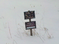
ACCESS DENIED.
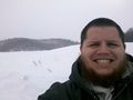
Stupid Grintm
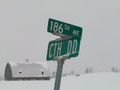
The Crossroads
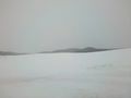
Just beyond that ridge
Not just me they're keeping out...


Achievements
Tom Schäffer earned the No trespassing consolation prize
|