Difference between revisions of "2011-02-17 53 -1"
imported>Monty |
imported>Monty m |
||
| Line 47: | Line 47: | ||
<!-- Add any achievement ribbons you earned below, or remove this section --> | <!-- Add any achievement ribbons you earned below, or remove this section --> | ||
Anticipated: Land, No Batteries. | Anticipated: Land, No Batteries. | ||
| + | |||
Possible, but unlikely: Speed racer. | Possible, but unlikely: Speed racer. | ||
| + | |||
Would be nice: Meet-up. | Would be nice: Meet-up. | ||
| + | |||
Would be ''very'' nice: Migration. | Would be ''very'' nice: Migration. | ||
| + | |||
In either case, someone gets: Earliest Geohasher. | In either case, someone gets: Earliest Geohasher. | ||
Revision as of 19:21, 16 February 2011
| Thu 17 Feb 2011 in 53,-1: 53.3744886, -1.4122742 geohashing.info google osm bing/os kml crox |
Location
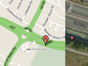
Close to the junction between A57 'Sheffield Parkway' A6102 Prince Of Wales Road, in-between a sliproad onto that junction and a cycle-path/pavement running parallel to it. The best Google Maps interpretation suggests it is under a tree between the two.
Participants
TBA: Monty is proposing to visit between 11am and 12pm, but is unsure if there's any other interest in the vicinity.
Plans
By car, after a meeting in Sheffield that morning, Monty will travel by car along the Parkway, and immediately after the A6102 junction take the sliproad up onto the raised roundabout where the Sheffield Parkway (A57 from Sheffield, becoming A630 towards J33 of M1) 'meets' A57 (eventually 'Aston Way', leading to J31 of M1 by passing through the various Mosborough Townships).
After encircling that flyover roundabout, heading back westwards, he'll keep off of the "back onto the A57 to Sheffield centre" sliproad and arrive at the A6102 island. It's not strictly necessary to have done this (exit direct to A6102 is possible) but if traffic and road conditions allow it means a potential Speedracer Achievement if a future GPS survey shows the point to actually be on the sliproad!
Regardless, exit south onto the A6102, then straight into "Parkway Service Station" and possibly the Travelodge car-park. (If it looks unsuitable (or too full) to park there for a maximum of 15 minutes, there are other streets within a few minute's walk.
The service station/Travelodge exit crosses over the pathway, so head there (watching traffic) and head east for no more than 150yds. There should be some identifiable points on the overhead allowing the correct point to be found. A compass will be taken on this trip, if needed for triangulation with various bits of identifiable shrubbery/etc. (But there's this idea I have for a "Free of Indicating Electronics Locale Divining" (FIELD) device...)
Then: mark (at least temporarily), photograph, look around for anyone else having marked already, go "Bother!" if such a mark is found elsewhere...
Exit plan: Walk back to car, drive away.
Expedition
Tale to be told...
Tracklog
Probably no tracklog available, afterwards, unless you go and have one.
Photos
I haven't gotten back and posted any yet... Be patient.
Achievements
Anticipated: Land, No Batteries.
Possible, but unlikely: Speed racer.
Would be nice: Meet-up.
Would be very nice: Migration.
In either case, someone gets: Earliest Geohasher.
