Difference between revisions of "2011-04-02 40 -104"
From Geohashing
imported>AkiTensai |
imported>AkiTensai |
||
| Line 44: | Line 44: | ||
| longitude = -104 | | longitude = -104 | ||
| date = 2011-04-02 | | date = 2011-04-02 | ||
| − | | name = AkiTensai | + | | name = [[User:AkiTensai|AkiTensai]], JediMaster, and [[User:Stringgeek|Stringgeek]] |
| image = 2011-04-02 40 -104 So Close So Far.jpg | | image = 2011-04-02 40 -104 So Close So Far.jpg | ||
}} | }} | ||
Revision as of 23:17, 10 April 2011
| Sat 2 Apr 2011 in 40,-104: 40.2684066, -104.8820211 geohashing.info google osm bing/os kml crox |
Location
Near Co Rd 19 and Co Rd 38, about 5 miles from I-25
Participants
- AkiTensai
- JediMaster
- Stringgeek
Plans
As the spot is 1000 ft off of a paved road, not much in the way of plans needed.
Expedition
The trip by pickup was as uneventful as the trip back. AkiTensai failed a diplomacy roll for permission to get onto the property. We camped the road from 3:45p to 4:05p waiting to see if anyone else might show. Got bored and went to see a movie. Got pictures towards the Geohash from about 1000 ft away.
Photos
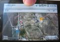
GPS w/Date
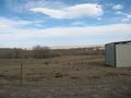
So close, yet so far.

Jedi was just happy to be there.
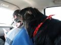
Jedi overwatching Aki navigate for JediMaster.


Achievements
AkiTensai, JediMaster, and Stringgeek earned the No trespassing consolation prize
|