Difference between revisions of "2011-05-09 47 -119"
From Geohashing
imported>Jiml (Start Report) |
imported>FippeBot m (Location) |
||
| Line 44: | Line 44: | ||
[[Category:Not reached - No public access]] | [[Category:Not reached - No public access]] | ||
[[Category:Expeditions with photos]] | [[Category:Expeditions with photos]] | ||
| + | {{location|US|WA|GN}} | ||
Latest revision as of 06:28, 9 August 2019
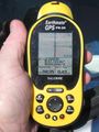
| Mon 9 May 2011 in Moses Lake, Washington: 47.7665049, -119.1789841 geohashing.info google osm bing/os kml crox |
Location
Near Banks Lake Wildlife Area
Participants
Plans
We were at Moses Lake on our way to Canada and this was on the way.
Expedition
A short sidetrip into the ranch lands of the Washington high desert (I think that is the land classification here). I was hoping that it would just be open west to WA 155 but it was fenced and posted.
So we stopped 1/2 mi. East on Rd 'O' N.E. The nearest landmark was @ 'O' & 47. I love the land survey squares!
Photos
Closest
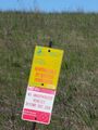
Sign
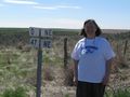
Kate
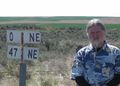
Dennis


Achievements
kydlt earned the No trespassing consolation prize
|