Difference between revisions of "2011-05-10 51 -0"
(Created page with "<!-- [[Image:{{{image|IMAGE}}}|thumb|left]] --> {{meetup graticule | lat=51 | lon=-0 | date=2011-05-10 }} __NOTOC__ == Location == In the exact middle of an M4 motorway bridge,...") |
imported>FippeBot m (Location) |
||
| (8 intermediate revisions by 2 users not shown) | |||
| Line 11: | Line 11: | ||
== Participants == | == Participants == | ||
| − | + | [[User:MattLondon|MattLondon]] went -- as close as was legal. | |
== Plans == | == Plans == | ||
| − | Cycle along the Grand Union Canal (Brentford Branch), walk over the lock to "Osterly | + | Cycle along the Grand Union Canal (Brentford Branch), walk over the lock to "Osterly Lock" (according to the OS map). |
I don't drive, so I can't use the M4; the railway has no passenger trains. | I don't drive, so I can't use the M4; the railway has no passenger trains. | ||
| − | |||
== Expedition == | == Expedition == | ||
| + | Osterley Lock looked overgrown, and there was nowhere to leave my bike. I continued along the canal to Trumpers Way, locked my bike to a fence and crossed the railway via the footpath. It was easy to follow the little-used path near the edge of the railway towards the motorway. | ||
| − | + | I could get to within 50m of the point, but no closer. Google Maps may be inaccurate, it's possible the point wasn't actually on the motorway, but in the private golf course on the other side. | |
== Photos == | == Photos == | ||
| − | |||
| − | |||
<gallery perrow="5"> | <gallery perrow="5"> | ||
| − | |||
| − | == | + | Image:2011-05-10_51_-0_19-21-08-669.jpg | Standing against the railway fence. The point is under the bridge. [http://www.openstreetmap.org/?lat=51.49612784385681&lon=-0.33528149127960205&zoom=16&layers=B000FTF @51.4961,-.3353] |
| − | |||
| − | |||
| − | |||
| − | -- | + | Image:2011-05-10_51_-0_20-16-02-446.jpg | I think the point is in the middle, a few metres in front of where the blue sign is. |
| − | + | Image:2011-05-10_51_-0_20-41-24-170.jpg | Trespassing on the seemingly little-used railway could have been fatal (the tiny red and white sign means "No clearance") [http://www.openstreetmap.org/?lat=51.496155lon=-0.3352861&zoom=16&layers=B000FTF @51.496155,-.3352861] | |
| − | + | </gallery> | |
| − | |||
| − | |||
| − | -- | ||
| − | |||
| − | |||
| − | |||
| − | -- | ||
| − | |||
| − | < | ||
| − | |||
| − | |||
| − | + | [[Category:Expeditions]] | |
| − | + | [[Category:Expeditions with photos]] | |
| − | + | [[Category:Coordinates not reached]] | |
| − | + | [[Category:Not reached - No public access]] | |
| − | + | {{location|GB|ENG|HNS}} | |
| − | |||
| − | |||
| − | |||
Latest revision as of 06:28, 9 August 2019
| Tue 10 May 2011 in 51,-0: 51.4957903, -0.3347794 geohashing.info google osm bing/os kml crox |
Location
In the exact middle of an M4 motorway bridge, in the exact middle of a freight-only railway, near Brentford/Hanwell.
Participants
MattLondon went -- as close as was legal.
Plans
Cycle along the Grand Union Canal (Brentford Branch), walk over the lock to "Osterly Lock" (according to the OS map).
I don't drive, so I can't use the M4; the railway has no passenger trains.
Expedition
Osterley Lock looked overgrown, and there was nowhere to leave my bike. I continued along the canal to Trumpers Way, locked my bike to a fence and crossed the railway via the footpath. It was easy to follow the little-used path near the edge of the railway towards the motorway.
I could get to within 50m of the point, but no closer. Google Maps may be inaccurate, it's possible the point wasn't actually on the motorway, but in the private golf course on the other side.
Photos
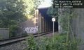
Standing against the railway fence. The point is under the bridge. @51.4961,-.3353
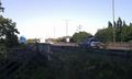
I think the point is in the middle, a few metres in front of where the blue sign is.
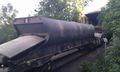
Trespassing on the seemingly little-used railway could have been fatal (the tiny red and white sign means "No clearance") @51.496155,-.3352861


