2011-05-21 40 -74
From Geohashing
Revision as of 07:33, 22 May 2011 by imported>Jevanyn ([retro picture] Shockingly, this map was useful.)
| Sat 21 May 2011 in 40,-74: 40.3363335, -74.6496377 geohashing.info google osm bing/os kml crox |
Location
D & R Canal path, in Princeton Township. The tow path on the east side of the canal is the dividing line between Princeton and West Windsor Township [1], so the margin for error overlaps the border.
Participants
- Jevanyn will try to make it at 4PM, time is somewhat flexible, and I may be bringing Evan and/or other dragalongs.
Plans
- Jevanyn: I've been in the area a hundred times, as 206 is my regular route to Cape May. I can't make it in the morning, but I'm going to make an effort to be there if there is a meetup.
Also of interest
The Berlin meetup is a 4PM European time, which is 10AM here.
Expedition
- Feh. Google Maps lied; there was no trail on the east side of the canal. Starting from Alexander Rd., a short gravely path leads to a fenced off power station just before the train line. Beyond the train tracks is a grassy way, but it was flooded in places. I made the closest approach possible on the opposite side of the canal. If I'd come earlier, and if there had been more people (ahem) I could have rented a canoe and gotten closer, but I was (briefly) within the margin of error for my GPS.
Not knowing the lay of the land (GPS malfunctioning until after I got to the trailhead) I ended up parked about a mile from the canal. It started to rain just as I headed back. -- Jevanyn 03:31, 22 May 2011 (EDT)
Tracklog
Photos
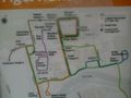
Shockingly, this map was useful.

Achievements