Difference between revisions of "2011-06-01 53 10"
imported>Bierhefe (planning) |
imported>FippeBot m (Location) |
||
| (10 intermediate revisions by 2 users not shown) | |||
| Line 1: | Line 1: | ||
| − | + | [[Image:2011-06-01-003.JPG|thumb|left]] | |
| − | |||
| − | [[Image: | ||
| − | |||
| − | |||
| − | |||
| − | |||
| − | |||
| − | |||
{{meetup graticule | {{meetup graticule | ||
| lat=53 | | lat=53 | ||
| Line 15: | Line 7: | ||
__NOTOC__ | __NOTOC__ | ||
| + | |||
| + | |||
| + | |||
| + | |||
| + | |||
| + | |||
| + | |||
| + | |||
| + | |||
| + | |||
| + | |||
== Location == | == Location == | ||
| − | On a field near Curslack/Neuengamme. The hash might be | + | On a field near Curslack/Neuengamme. The hash might be inaccessible, though. Google Maps doesn't show any paths that get close enough to the hash point. [[2011-03-03 53 10|I learned from another expedition]] that it isn't exactly a smart move to run around on fields... |
== Participants == | == Participants == | ||
| Line 22: | Line 25: | ||
== Plans == | == Plans == | ||
| − | I plan to cycle to the hash at around 3 pm. | + | Bierhefe - I plan to cycle to the hash at around 3 pm. |
== Expedition == | == Expedition == | ||
| − | + | When I learned that today hash point would be close by I decided I will try to reach it. It happens rarely that the hash point is so close, so I have to take my chance, right? | |
| + | A closer inspection via OpenStreetMap and GoogleMaps indicated, that this hash point might be inaccessible. There was some kind of road very close to the hash point, but it didn't show up on any map. Google Street View showed a gate just in front of this road and some signs, but it's not possible to read the signs in Street View. Anyway, I still wanted to try my luck. | ||
| + | |||
| + | Today I started the expedition at around 14:40 (2:40 pm). The way to the hash was very uneventful, only a few turns here and there, mostly downhill... then I crossed a bridge and got into Curslack. The first time I was here, I realized. I tried to find the road and found the gate was actually open. But this was of no use for me, since one of the signs said "Protected Area for Wells" and "No Trespassing". Since I don't have any special clearance I couldn't use this path. | ||
| + | |||
| + | I tried a different approach via a side road (where I also found a geocache), but getting to the hash would've meant to walk over a field with crops, thus causing quite some damage. I decided against this approach. I thought of a third approach, but the thought "If this is a protected area, I shouldn't mess around there anyway" crossed my mind, so I called it a day and headed back home. | ||
| + | |||
| + | On my way back I nearly collided with a dog. The dog apparently thought it was a good idea to jump right in front of my bike and bark at me like it was going mad. Luckily I was able to hit the breaks quick enough and luckily again the owner called the dog, so it finally went out of my way. It was still a huge shock when that animal suddenly jumped in front of me. :/ | ||
| + | |||
| + | Anyway, the weather was very nice today, so it was a nice bicycle ride, even though I didn't reach the coordinates. Also, this was the first bicycle geohashe attempt where I didn't had to use the bus for parts of the way back, due to being totally exhausted. I used my bike more often in the last few weeks and it really shows now. :) | ||
== Tracklog == | == Tracklog == | ||
| − | + | [http://waka.bplaced.net/geohash/2011-06-01_53_10.gpx Here] or on [http://www.everytrail.com/view_trip.php?trip_id=1119222 everytrail]. I took a slightly different route on my way back. Also, I mapped some paths for OSM. | |
== Photos == | == Photos == | ||
| − | <!-- | + | <gallery perrow="4"> |
| − | Image: | + | Image:2011-06-01-001.JPG | Nice Scenery |
| − | -- | + | Image:2011-06-01-002.JPG | The road |
| − | + | Image:2011-06-01-003.JPG | No trespassing! | |
| + | Image:2011-06-01-004.JPG | Gates are open, but it's of no use for me | ||
| + | Image:2011-06-01-005.JPG | 1.5km away from the hash | ||
| + | Image:2011-06-01-006.JPG | The hash is somewhere on this picture | ||
| + | Image:2011-06-01-007.JPG | A kitty! | ||
| + | Image:2011-06-01-008.JPG | Wind engines | ||
| + | Image:2011-06-01-009.JPG | 760m from the hash. Closest I got. | ||
| + | Image:2011-06-01-010.JPG | Coordinates... | ||
| + | Image:2011-06-01-011.JPG | not reached! | ||
</gallery> | </gallery> | ||
== Achievements == | == Achievements == | ||
{{#vardefine:ribbonwidth|800px}} | {{#vardefine:ribbonwidth|800px}} | ||
| − | + | {{No trespassing | |
| + | | latitude = 53 | ||
| + | | longitude = 10 | ||
| + | | date = 2011-06-01 | ||
| + | | name = [[User:Bierhefe|Bierhefe]] | ||
| + | | image = | ||
| + | }} | ||
| − | |||
| − | |||
| − | |||
| − | |||
| − | |||
[[Category:Expeditions]] | [[Category:Expeditions]] | ||
| − | |||
[[Category:Expeditions with photos]] | [[Category:Expeditions with photos]] | ||
| − | |||
| − | |||
| − | |||
| − | |||
| − | |||
| − | |||
| − | |||
| − | |||
| − | |||
[[Category:Coordinates not reached]] | [[Category:Coordinates not reached]] | ||
| − | + | [[Category:Not reached - No public access]] | |
| − | + | {{location|DE|HH}} | |
| − | [[Category:Not reached - No public access]] | ||
| − | |||
| − | |||
| − | |||
Latest revision as of 06:44, 9 August 2019

| Wed 1 Jun 2011 in 53,10: 53.4526587, 10.2514905 geohashing.info google osm bing/os kml crox |
Location
On a field near Curslack/Neuengamme. The hash might be inaccessible, though. Google Maps doesn't show any paths that get close enough to the hash point. I learned from another expedition that it isn't exactly a smart move to run around on fields...
Participants
Bierhefe will try his luck tomorrow.
Plans
Bierhefe - I plan to cycle to the hash at around 3 pm.
Expedition
When I learned that today hash point would be close by I decided I will try to reach it. It happens rarely that the hash point is so close, so I have to take my chance, right? A closer inspection via OpenStreetMap and GoogleMaps indicated, that this hash point might be inaccessible. There was some kind of road very close to the hash point, but it didn't show up on any map. Google Street View showed a gate just in front of this road and some signs, but it's not possible to read the signs in Street View. Anyway, I still wanted to try my luck.
Today I started the expedition at around 14:40 (2:40 pm). The way to the hash was very uneventful, only a few turns here and there, mostly downhill... then I crossed a bridge and got into Curslack. The first time I was here, I realized. I tried to find the road and found the gate was actually open. But this was of no use for me, since one of the signs said "Protected Area for Wells" and "No Trespassing". Since I don't have any special clearance I couldn't use this path.
I tried a different approach via a side road (where I also found a geocache), but getting to the hash would've meant to walk over a field with crops, thus causing quite some damage. I decided against this approach. I thought of a third approach, but the thought "If this is a protected area, I shouldn't mess around there anyway" crossed my mind, so I called it a day and headed back home.
On my way back I nearly collided with a dog. The dog apparently thought it was a good idea to jump right in front of my bike and bark at me like it was going mad. Luckily I was able to hit the breaks quick enough and luckily again the owner called the dog, so it finally went out of my way. It was still a huge shock when that animal suddenly jumped in front of me. :/
Anyway, the weather was very nice today, so it was a nice bicycle ride, even though I didn't reach the coordinates. Also, this was the first bicycle geohashe attempt where I didn't had to use the bus for parts of the way back, due to being totally exhausted. I used my bike more often in the last few weeks and it really shows now. :)
Tracklog
Here or on everytrail. I took a slightly different route on my way back. Also, I mapped some paths for OSM.
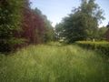
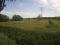
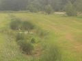
Photos
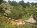
Nice Scenery
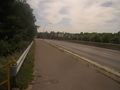
The road
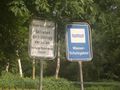
No trespassing!
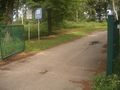
Gates are open, but it's of no use for me
1.5km away from the hash
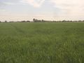
The hash is somewhere on this picture
A kitty!
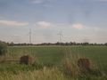
Wind engines
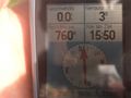
760m from the hash. Closest I got.
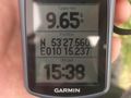
Coordinates...
not reached!


Achievements
Bierhefe earned the No trespassing consolation prize
|