Difference between revisions of "2011-06-17 48 9"
From Geohashing
imported>Hijackal m (Link: user page) |
imported>Hijackal (→Photos) |
||
| Line 36: | Line 36: | ||
--> | --> | ||
<gallery perrow="5"> | <gallery perrow="5"> | ||
| + | Image:2011-06-17 48 9 Mountaintop.png | The top of the Blasiberg - I'm almost there! | ||
| + | Image:2011-06-17 48 9 hashmeadow.png | I can see daylight! (and probably the hash somwhere between the trees on the left) | ||
| + | Image:2011-06-17 48 9 screen.png | Yay! | ||
| + | Image:2011-06-17_48_9_spotthegps.png | Yes, there is more than grass in this picture. | ||
</gallery> | </gallery> | ||
Revision as of 09:36, 3 July 2011
| Fri 17 Jun 2011 in 48,9: 48.5741786, 9.6052638 geohashing.info google osm bing/os kml crox |
Location
A field/meadow on the Bläsiberg, just off the A8 near Wiesensteig.
Participants
Plans
I'm driving to Ulm, need to go by car unfortunately. If my spare time doesn't get eaten by traffic, I'll get off the A8 and visit the hash at about 11.
Expedition
Tracklog
Photos
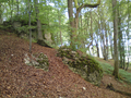
The top of the Blasiberg - I'm almost there!
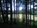
I can see daylight! (and probably the hash somwhere between the trees on the left)
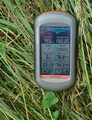
Yay!
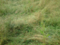
Yes, there is more than grass in this picture.


Achievements