Difference between revisions of "2011-07-16 44 -118"
From Geohashing
imported>Michael5000 |
imported>Michael5000 m |
||
| Line 16: | Line 16: | ||
<!-- edit as necessary --> | <!-- edit as necessary --> | ||
__NOTOC__ | __NOTOC__ | ||
| − | File:2011-07-16 44 -118 sign.JPG|left|500 px | + | [[File:2011-07-16 44 -118 sign.JPG|left|500 px]] |
== Location == | == Location == | ||
| Line 36: | Line 36: | ||
<gallery perrow="5"> | <gallery perrow="5"> | ||
| − | File:2011-07-16 44 -118 | + | File:2011-07-16 44 -118 point.JPG|Looking toward the hashpoint from Pine Creek Road. |
File:2011-07-16 44 -118 sign.JPG|Junction of Pine Creek Road and Highway 26. | File:2011-07-16 44 -118 sign.JPG|Junction of Pine Creek Road and Highway 26. | ||
</gallery> | </gallery> | ||
Revision as of 03:31, 17 July 2011
| Sat 16 Jul 2011 in 44,-118: 44.4212630, -118.8338070 geohashing.info google osm bing/os kml crox |

Location
In the John Day Valley between John Day and Prairie City.
Participants
Expedition
This was the first known attempt to hash the Prairie City graticule. From the aerial imagery, it looked possible that this hashpoint might be accessible by a short walk across an open field. Unlikely and, as it turned out, not so: ground zero was well over into fenced agricultural land.
Expedition Twarted.
Photos
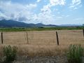
Looking toward the hashpoint from Pine Creek Road.
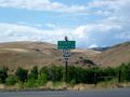
Junction of Pine Creek Road and Highway 26.
