Difference between revisions of "2011-07-18 55 12"
From Geohashing
imported>Bjuhn ([live picture] [http://www.openstreetmap.org/?lat=55.6124&lon=12.4609&zoom=16&layers=B000FTF @55.6124,12.4609]) |
imported>Bjuhn |
||
| Line 1: | Line 1: | ||
| − | |||
<!-- If you did not specify these parameters in the template, please substitute appropriate values for IMAGE, LAT, LON, and DATE (YYYY-MM-DD format) | <!-- If you did not specify these parameters in the template, please substitute appropriate values for IMAGE, LAT, LON, and DATE (YYYY-MM-DD format) | ||
| Line 15: | Line 14: | ||
}} | }} | ||
| − | |||
__NOTOC__ | __NOTOC__ | ||
== Location == | == Location == | ||
| − | + | Todays hash fell in the Avedøre Holme industrial comlex south of Hvidovre in what turned out to be a military facility. | |
== Participants == | == Participants == | ||
| − | + | [[User:Bjuhn|bjuhn]] | |
== Plans == | == Plans == | ||
| Line 28: | Line 26: | ||
== Expedition == | == Expedition == | ||
<!-- how it all turned out. your narrative goes here. --> | <!-- how it all turned out. your narrative goes here. --> | ||
| − | |||
| − | |||
| − | |||
== Photos == | == Photos == | ||
| Line 43: | Line 38: | ||
</gallery> | </gallery> | ||
| − | |||
| − | |||
| − | |||
| − | |||
| − | |||
| − | |||
| − | |||
| − | |||
| − | |||
| − | |||
| − | |||
| − | |||
| − | |||
| − | |||
| − | |||
[[Category:Expeditions]] | [[Category:Expeditions]] | ||
| − | |||
[[Category:Expeditions with photos]] | [[Category:Expeditions with photos]] | ||
| − | |||
| − | |||
| − | |||
| − | |||
| − | |||
| − | |||
| − | |||
| − | |||
| − | |||
[[Category:Coordinates not reached]] | [[Category:Coordinates not reached]] | ||
| − | |||
| − | |||
[[Category:Not reached - No public access]] when there is a man-made obstacle between you and the target | [[Category:Not reached - No public access]] when there is a man-made obstacle between you and the target | ||
| − | |||
| − | |||
| − | |||
Revision as of 05:51, 19 July 2011
| Mon 18 Jul 2011 in 55,12: 55.6128470, 12.4626463 geohashing.info google osm bing/os kml crox |
Location
Todays hash fell in the Avedøre Holme industrial comlex south of Hvidovre in what turned out to be a military facility.
Participants
Plans
Expedition
Photos
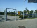
As it turns out, todays geohash is located inside a military facility... @55.6124,12.4608


when there is a man-made obstacle between you and the target