Difference between revisions of "2011-07-24 45 -123"
From Geohashing
imported>Michael5000 (Created page with "{{subst:Expedition |lat = 45 |lon = -123 |date = 2011-07-24 }}") |
imported>FippeBot m (Location) |
||
| (7 intermediate revisions by 2 users not shown) | |||
| Line 1: | Line 1: | ||
| − | |||
| − | |||
| − | |||
| − | |||
| − | |||
| − | |||
| − | |||
| − | |||
| − | |||
| − | |||
{{meetup graticule | {{meetup graticule | ||
| lat=45 | | lat=45 | ||
| Line 15: | Line 5: | ||
}} | }} | ||
| − | |||
__NOTOC__ | __NOTOC__ | ||
== Location == | == Location == | ||
| − | + | ||
| + | In the upland between Cannon Beach and Seaside. | ||
== Participants == | == Participants == | ||
| − | |||
| − | + | *[[User:Michael5000|Michael5000]] | |
| − | + | *[[User:Mrs.5000|Mrs.5000]] | |
| + | *Jennifer | ||
== Expedition == | == Expedition == | ||
| − | |||
| − | + | This may win the prize for Most Anticlimactic Expedition in the 5000s' experience. We saw what looked to be an easily accessible woodsy hashpoint on the Coast, which inspired us and our visiting guest geohasher to launch an 80 mile attempt. We provisioned ourselves appropriately, then drove and drove and drove and drove and drove and reached the turnoff from Highway 101, where we promptly ran into no-nonsense gates declaring that the area was an active quarry site. They didn't specifically ban geohashing, but you could tell that this was their general mindset. | |
| − | + | ||
| + | So we went to the beach. | ||
| + | |||
| + | Expedition Thwarted. | ||
== Photos == | == Photos == | ||
| − | |||
| − | |||
| − | |||
<gallery perrow="5"> | <gallery perrow="5"> | ||
| + | File:2011-07-24 45 -123 45 -123.JPG|Well, that's that. | ||
</gallery> | </gallery> | ||
== Achievements == | == Achievements == | ||
{{#vardefine:ribbonwidth|800px}} | {{#vardefine:ribbonwidth|800px}} | ||
| − | |||
| + | {{drag-along | ||
| + | | latitude = 45 | ||
| + | | longitude = -122 | ||
| + | | date = 2011-07-23 | ||
| + | | partner = Jennifer | ||
| + | | name = Michael5000 | ||
| + | }} | ||
| − | |||
| − | |||
| − | |||
| − | |||
| − | |||
| − | |||
| − | |||
| − | |||
| − | |||
| − | |||
[[Category:Expeditions]] | [[Category:Expeditions]] | ||
| − | |||
[[Category:Expeditions with photos]] | [[Category:Expeditions with photos]] | ||
| − | |||
| − | |||
| − | |||
| − | |||
| − | |||
| − | |||
| − | |||
| − | |||
| − | |||
[[Category:Coordinates not reached]] | [[Category:Coordinates not reached]] | ||
| − | + | [[Category:Not reached - No public access]] | |
| − | + | {{location|US|OR|CT}} | |
| − | [[Category:Not reached - No public access]] | ||
| − | |||
| − | |||
| − | |||
Latest revision as of 00:14, 13 August 2019
| Sun 24 Jul 2011 in 45,-123: 45.9434130, -123.9556049 geohashing.info google osm bing/os kml crox |
Location
In the upland between Cannon Beach and Seaside.
Participants
- Michael5000
- Mrs.5000
- Jennifer
Expedition
This may win the prize for Most Anticlimactic Expedition in the 5000s' experience. We saw what looked to be an easily accessible woodsy hashpoint on the Coast, which inspired us and our visiting guest geohasher to launch an 80 mile attempt. We provisioned ourselves appropriately, then drove and drove and drove and drove and drove and reached the turnoff from Highway 101, where we promptly ran into no-nonsense gates declaring that the area was an active quarry site. They didn't specifically ban geohashing, but you could tell that this was their general mindset.
So we went to the beach.
Expedition Thwarted.
Photos
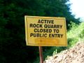
Well, that's that.

Achievements
Michael5000 earned the Drag-along achievement
|