Difference between revisions of "2011-08-17 1 103"
imported>Cyazlars (Created page with "{{meetup graticule | lat=1 | lon=103 | date=2011-07-16 | graticule_name=Singapore | graticule_link=Singapore, Singapore}} ==Location== Somewhere in Tanglin Camp, along Loewen Ro...") |
imported>FippeBot m (Location) |
||
| (3 intermediate revisions by one other user not shown) | |||
| Line 2: | Line 2: | ||
| lat=1 | | lat=1 | ||
| lon=103 | | lon=103 | ||
| − | | date=2011- | + | | date=2011-08-17 |
| graticule_name=Singapore | | graticule_name=Singapore | ||
| graticule_link=Singapore, Singapore}} | | graticule_link=Singapore, Singapore}} | ||
| Line 13: | Line 13: | ||
==Expedition== | ==Expedition== | ||
| − | + | I set out from school at around 12.50pm, walking to the bus stop along Thomson Road to catch the bus service 132. After a half-hour bus ride, I alighted at Tanglin Road and walked into Ridley Park, walking for about ten minutes before I finally reached Loewen Road. And there were two Loewen Roads, one moving on straight from Ridley Park and the other branching off a little way uphill. The one I needed to follow was the one going uphill, but when I got there the road...well, wasn't really there anymore. Most of it was fenced off, and whatever little there was left that I could see had been covered with overgrown grass. I walked a little way around the perimeter with Geohash Droid on, hopefully looking for a clear way in, but no such luck. My mum told me Tanglin Camp had been converted into an F&B hangout so I was hoping it would be much more open, but I guess not the part where the geohash was located, unfortunately. | |
| + | |||
| + | Later on I looked at the map again, there was another opening to this Loewen Road on the other side of the camp, but I have no idea whether it would have been an open route or similarly fenced. No point thinking about it, now! | ||
==Photos== | ==Photos== | ||
| + | <gallery perrow="3"> | ||
| + | Image:2011_08_17_1_103_busstop_(1024x768).jpg| | ||
| + | Image:2011_08_17_1_103_ridleypark_(1024x768).jpg| | ||
| + | Image:2011_08_17_1_103_junction_(1024x768).jpg| | ||
| + | Image:2011_08_17_1_103_tanglinvillage_(1024x768).jpg| | ||
| + | Image:2011_08_17_1_103_sign_(1024x768).jpg| | ||
| + | Image:2011_08_17_1_103_creepy_(1024x768).jpg| | ||
| + | Image:2011_08_17_1_103_fenced_(1024x768).jpg|The geohash was about 79m from here. | ||
| + | Image:2011_08_17_1_103_fenced2_(1024x768).jpg|Well actually, it <i>is</i> kind of creepy. | ||
| + | Image:2011_08_17_1_103_anothercastle_(1024x768).jpg|Where one of the Loewen Roads used to be... | ||
| + | </gallery> | ||
| − | + | [[Category:Coordinates not reached]] | |
| + | [[Category:Not reached - No public access]] | ||
| − | [[Category: | + | [[Category:Expeditions]] |
| + | [[Category:Expeditions with photos]] | ||
| + | {{location|SG|CS}} | ||
Latest revision as of 00:28, 13 August 2019
| Wed 17 Aug 2011 in Singapore: 1.3012323, 103.8123729 geohashing.info google osm bing/os kml crox |
Contents
Location
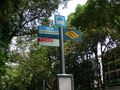
Somewhere in Tanglin Camp, along Loewen Road.
Participants
Expedition
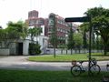
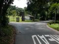
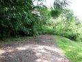
I set out from school at around 12.50pm, walking to the bus stop along Thomson Road to catch the bus service 132. After a half-hour bus ride, I alighted at Tanglin Road and walked into Ridley Park, walking for about ten minutes before I finally reached Loewen Road. And there were two Loewen Roads, one moving on straight from Ridley Park and the other branching off a little way uphill. The one I needed to follow was the one going uphill, but when I got there the road...well, wasn't really there anymore. Most of it was fenced off, and whatever little there was left that I could see had been covered with overgrown grass. I walked a little way around the perimeter with Geohash Droid on, hopefully looking for a clear way in, but no such luck. My mum told me Tanglin Camp had been converted into an F&B hangout so I was hoping it would be much more open, but I guess not the part where the geohash was located, unfortunately.
Later on I looked at the map again, there was another opening to this Loewen Road on the other side of the camp, but I have no idea whether it would have been an open route or similarly fenced. No point thinking about it, now!
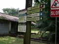
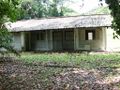
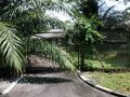
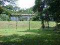
Photos
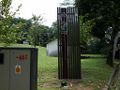
The geohash was about 79m from here.
Well actually, it is kind of creepy.
Where one of the Loewen Roads used to be...
.jpg)
.jpg)
.jpg)
.jpg)
.jpg)
.jpg)
.jpg)
.jpg)
.jpg)