2011-11-27 48 -123
From Geohashing
Revision as of 04:43, 29 November 2011 by imported>Wijnland (→Photos)
| Sun 27 Nov 2011 in 48,-123: 48.9273738, -123.5665312 geohashing.info google osm bing/os kml crox |
Location
An island near Vancouver
Participants
Plans
My plan is to visit this location starting from Vancouver:
- Bike to Bridgeport bus exchange
- Bus 620 (with bike) to Twassen ferry
- Ferry Tswassen - Swartzbay
- Ferry Swartzbay - Fulford Harbour
- Bike around Saltspring Island to reach the geohash at the north end
- Ferry LongHarbour - Tswassen
- Bus back to Bridgeport
- Skytrain to get close to my house since I will be tired and to get an extra mode of transportation.
If most things work out, I will not get stuck on this island missing the last ferry...
Expedition
Succes!, more soon.
Tracklog
Photos

GPS showing the geohash is reached
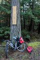
My bike parked at opposite site of the location, street nr made it an easy find as it was clearly visible on streetview

Nice Landscape in Infrared pictured at geohash trip

Nice Land\Waterscape pictured on the return ferry
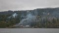
In the morning the weather was stil cloud&rain, but it only got better!


Achievements
I should get some achievement for the most elaborate first geohash plan, and for using 5+ different types of transportation.