Difference between revisions of "2011-12-03 49 -123"
imported>Wijnland (→Expedition) |
imported>Wijnland |
||
| Line 18: | Line 18: | ||
== Location == | == Location == | ||
| − | Horseshoe Bay, Between Horeshoe bay Dr. and the | + | Horseshoe Bay, Between Horeshoe bay Dr. and the Sea to Sky Highway (99). |
== Participants == | == Participants == | ||
| − | + | * [[User:Wijnland|Wijnland]] | |
== Plans == | == Plans == | ||
| Line 29: | Line 29: | ||
== Expedition == | == Expedition == | ||
<!-- how it all turned out. your narrative goes here. --> | <!-- how it all turned out. your narrative goes here. --> | ||
| − | + | All went a bit later than planned... Left home around 11.00 and arrived very close to the geohash about 1h30' later. The bikeride was really good, quite a bit of hills though. At the site I planned on walking into the woods for some 20-30meters, but faced a rather high cliff. In the End I walked all the way around to reach the destination, Victory! I did not do anything stupid or dangerous to get back tot to my bike quickly. The tour around took quite long, so arrived very late at my other plans for the day. | |
== Tracklog == | == Tracklog == | ||
<!-- if your GPS device keeps a log, you may post a link here --> | <!-- if your GPS device keeps a log, you may post a link here --> | ||
| + | File:Geohash_20111203N48W123_A.png | ||
== Photos == | == Photos == | ||
| Line 39: | Line 40: | ||
--> | --> | ||
<gallery perrow="5"> | <gallery perrow="5"> | ||
| + | Image:2011120348-123_A.jpg | Only 28m to go... | ||
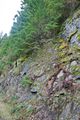
| + | Image:Geohash_20111203N48W123_B.png | My tour trough the woods to get safely to the top of the cliff. | ||
| + | Image:2011120348-123_6082.jpg | Great view from the top of the cliff. | ||
| + | Image:2011120348-123_6090.jpg | Destination reached | ||
| + | Image:2011120348-123_6092.jpg | Yes, I was there! | ||
| + | Image:2011120348-123_6098.jpg | not my route back | ||
| + | |||
</gallery> | </gallery> | ||
| Line 44: | Line 52: | ||
{{#vardefine:ribbonwidth|800px}} | {{#vardefine:ribbonwidth|800px}} | ||
<!-- Add any achievement ribbons you earned below, or remove this section --> | <!-- Add any achievement ribbons you earned below, or remove this section --> | ||
| + | {{Bicycle geohash | latitude = 48 | longitude = -123 | date = 2011-12-03 | name = Wijnland | distance = 57.5 km | image = 2011120348-123_A.jpg }} | ||
| + | {{consecutive geohash | count = 2 | latitude = 48 | longitude = -123 | date = 2011-12-02 | name = Wijnland }} | ||
| Line 49: | Line 59: | ||
Delete the next line ONLY if you have chosen the appropriate categories below. If you are unsure, don't worry. People will read your report and help you with the classification. --> | Delete the next line ONLY if you have chosen the appropriate categories below. If you are unsure, don't worry. People will read your report and help you with the classification. --> | ||
[[Category:New report]] | [[Category:New report]] | ||
| − | |||
| − | |||
| − | |||
| − | |||
<!-- An actual expedition: | <!-- An actual expedition: | ||
| Line 58: | Line 64: | ||
-- and one or more of -- | -- and one or more of -- | ||
[[Category:Expeditions with photos]] | [[Category:Expeditions with photos]] | ||
| − | |||
| − | |||
--> | --> | ||
<!-- if you reached your coords: | <!-- if you reached your coords: | ||
[[Category:Coordinates reached]] | [[Category:Coordinates reached]] | ||
| − | |||
| − | |||
| − | |||
| − | |||
| − | |||
| − | |||
| − | |||
| − | |||
| − | |||
--> | --> | ||
Revision as of 05:59, 5 December 2011
| Sat 3 Dec 2011 in 49,-123: 49.3781775, -123.2674228 geohashing.info google osm bing/os kml crox |
Location
Horseshoe Bay, Between Horeshoe bay Dr. and the Sea to Sky Highway (99).
Participants
Plans
Wijnland Goes for an early meetup (~11.00) as he has other plans in the afternoon.
Expedition
All went a bit later than planned... Left home around 11.00 and arrived very close to the geohash about 1h30' later. The bikeride was really good, quite a bit of hills though. At the site I planned on walking into the woods for some 20-30meters, but faced a rather high cliff. In the End I walked all the way around to reach the destination, Victory! I did not do anything stupid or dangerous to get back tot to my bike quickly. The tour around took quite long, so arrived very late at my other plans for the day.
Tracklog
File:Geohash_20111203N48W123_A.png
Photos
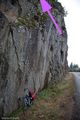
Only 28m to go...
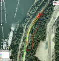
My tour trough the woods to get safely to the top of the cliff.
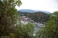
Great view from the top of the cliff.
Destination reached

Yes, I was there!
not my route back


Achievements
Wijnland earned the Bicycle geohash achievement
|
Wijnland earned the Consecutive geohash achievement
|