Difference between revisions of "2012-01-08 55 12"
imported>Nesk (→Plans) |
m |
||
| (14 intermediate revisions by 3 users not shown) | |||
| Line 1: | Line 1: | ||
| − | |||
<!-- If you did not specify these parameters in the template, please substitute appropriate values for IMAGE, LAT, LON, and DATE (YYYY-MM-DD format) | <!-- If you did not specify these parameters in the template, please substitute appropriate values for IMAGE, LAT, LON, and DATE (YYYY-MM-DD format) | ||
| Line 15: | Line 14: | ||
}} | }} | ||
| − | + | ||
__NOTOC__ | __NOTOC__ | ||
== Location == | == Location == | ||
| − | + | ||
| − | + | This was at the edge of a forest near Høsterkøb, [[wikipedia:Rudersdal Municipality|Rudersdal]], some 30 km North of [[wikipedia:Copenhagen|Copenhagen]], [[wikipedia:Denmark|Denmark]]. | |
== Participants == | == Participants == | ||
| − | [[User:Nesk|Nesk]] | + | * [[User:Nesk|Nesk]] |
== Plans == | == Plans == | ||
| − | A routine check of hash coordinates revealed that today's hash should be | + | A routine check of hash coordinates revealed that today's hash should be theoretically reachable by bike, being some 14 km from my home. While the first part of the route would mostly run through civilized lands, the latter part would send me through the woodlands of Geel Skov and Rude Skov. Most of the route was paved road, promising no major hindrances. The nature of the last few meters from the road to the hash could not be accurately determined from available maps; this was left as an explorative objective. |
== Expedition == | == Expedition == | ||
| − | + | I set of at around 13:30 by bike. Conditions were friendly considering the season. No precipitation at that time, although a dense cover of clouds adorned the skies. Temperatures approximated 5 degrees C, and winds some 7-10 m/s between N and NW. I would thus have the wind in my back when riding back home. | |
| + | |||
| + | The first few kilometers took me through well-known suburban terrain to [[wikipedia:Kongens Lyngby|Kongens Lyngby]]. | ||
| + | From there I headed North into unexplored lands towards [[wikipedia:Holte|Holte]], 5 kilometers from Kongens | ||
| + | Lyngby along straight road. This would take me trough the forest of Geel Skov. Upon approaching the edge of the forest I discovered the road I had chosen would treat me to a few hilltops. These were defeated by moderate effort. | ||
| + | |||
| + | Continuing though Holte to take the road NE through the larger Rude Skov, I left the [[wikipedia:Metropolitan Copenhagen|Copenhagen suburbs]] and entered the picturesque North Zealand countryside. Through the woods I rode, past lakes and more hilltops to the outskirts of the village of Høsterkøb. Consulting the GPS with ever increasing frequency I left the main road and moved through winding paths towards the hash, now less than 1 km away. | ||
| + | |||
| + | I found it the be located at the grounds of a horse factory, which I approached to [[wikipedia:Reconnaissance|scout]] whether the hash would be accessible. I followed a muddy road to a spot some 50 meters off the objective. Leaving the bike at a tree I went a few paces into the woods to discover the area containing the hash to be fenced off. I figured that, being at a horse factory, this fence was undoubtedly a measure undertaken by the management of the site in order to [[wikipedia:Biological containment|control the movement of horses]], a justification which I would readily and wholeheartedly condone. Unfortunately, the fence also prevented be from getting closer to the hash -- thus, with a mere 45 meters to go, I proceeded to take some pictures before heading home. | ||
| + | |||
| + | I reached home a short time before night fell at 16:00. | ||
| + | |||
| + | '''Conclusion''': | ||
| + | |||
| + | This was my first attempt at geohashing. The objective was, apart of course from reaching the hash itself, to do some exploration and to get some mud on my shoes and some exercise. While the hash was [[wikipedia:Frustration|not completely reached]], the remaining targets were fully met, and I am therefore [[wikipedia:Acceptance|quite satisfied]] with the outcome. | ||
== Tracklog == | == Tracklog == | ||
| Line 34: | Line 47: | ||
== Photos == | == Photos == | ||
| − | + | ||
| − | |||
| − | |||
<gallery perrow="5"> | <gallery perrow="5"> | ||
| + | Image: 2012_01_08_55_12_GeelSkov.jpg | Approaching the hill in Geel Skov from Kongens Lyngby | ||
| + | Image: 2012_01_08_55_12_Hoesterkoeb.jpg | Paths near Høsterkøb | ||
| + | Image: 2012_01_08_55_12_hash.jpg | Fence blocking the way to the hash, which should be just behind the hill. | ||
| + | Image: 2012_01_08_55_12_stable.jpg | A stable within the fenced area. | ||
| + | Image: 2012_01_08_55_12_lake.jpg | There was a lake on the other side of the road near the hash. | ||
</gallery> | </gallery> | ||
== Achievements == | == Achievements == | ||
{{#vardefine:ribbonwidth|800px}} | {{#vardefine:ribbonwidth|800px}} | ||
| − | |||
| − | + | {{No trespassing | |
| − | + | | latitude = 55 | |
| − | [[ | + | | longitude = 12 |
| + | | date = 2012-01-08 | ||
| + | | name = [[User:Nesk|Nesk]] | ||
| − | + | }} | |
| − | |||
| − | |||
| − | |||
| − | |||
[[Category:Expeditions]] | [[Category:Expeditions]] | ||
| − | + | ||
[[Category:Expeditions with photos]] | [[Category:Expeditions with photos]] | ||
| − | + | [[Category:Coordinates not reached]] | |
| − | |||
| − | |||
| − | |||
| − | |||
| − | [[Category:Coordinates reached]] | ||
| − | |||
| − | + | [[Category:Not reached - No public access]] | |
| − | + | {{location|DK|84}} | |
| − | |||
| − | |||
| − | [[Category:Not reached - No public access]] | ||
| − | |||
| − | |||
| − | |||
Latest revision as of 22:10, 3 March 2020
| Sun 8 Jan 2012 in 55,12: 55.8598338, 12.4800450 geohashing.info google osm bing/os kml crox |
Location
This was at the edge of a forest near Høsterkøb, Rudersdal, some 30 km North of Copenhagen, Denmark.
Participants
Plans
A routine check of hash coordinates revealed that today's hash should be theoretically reachable by bike, being some 14 km from my home. While the first part of the route would mostly run through civilized lands, the latter part would send me through the woodlands of Geel Skov and Rude Skov. Most of the route was paved road, promising no major hindrances. The nature of the last few meters from the road to the hash could not be accurately determined from available maps; this was left as an explorative objective.
Expedition
I set of at around 13:30 by bike. Conditions were friendly considering the season. No precipitation at that time, although a dense cover of clouds adorned the skies. Temperatures approximated 5 degrees C, and winds some 7-10 m/s between N and NW. I would thus have the wind in my back when riding back home.
The first few kilometers took me through well-known suburban terrain to Kongens Lyngby. From there I headed North into unexplored lands towards Holte, 5 kilometers from Kongens Lyngby along straight road. This would take me trough the forest of Geel Skov. Upon approaching the edge of the forest I discovered the road I had chosen would treat me to a few hilltops. These were defeated by moderate effort.
Continuing though Holte to take the road NE through the larger Rude Skov, I left the Copenhagen suburbs and entered the picturesque North Zealand countryside. Through the woods I rode, past lakes and more hilltops to the outskirts of the village of Høsterkøb. Consulting the GPS with ever increasing frequency I left the main road and moved through winding paths towards the hash, now less than 1 km away.
I found it the be located at the grounds of a horse factory, which I approached to scout whether the hash would be accessible. I followed a muddy road to a spot some 50 meters off the objective. Leaving the bike at a tree I went a few paces into the woods to discover the area containing the hash to be fenced off. I figured that, being at a horse factory, this fence was undoubtedly a measure undertaken by the management of the site in order to control the movement of horses, a justification which I would readily and wholeheartedly condone. Unfortunately, the fence also prevented be from getting closer to the hash -- thus, with a mere 45 meters to go, I proceeded to take some pictures before heading home.
I reached home a short time before night fell at 16:00.
Conclusion:
This was my first attempt at geohashing. The objective was, apart of course from reaching the hash itself, to do some exploration and to get some mud on my shoes and some exercise. While the hash was not completely reached, the remaining targets were fully met, and I am therefore quite satisfied with the outcome.
Tracklog
Photos
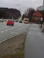
Approaching the hill in Geel Skov from Kongens Lyngby
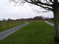
Paths near Høsterkøb
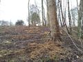
Fence blocking the way to the hash, which should be just behind the hill.
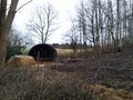
A stable within the fenced area.
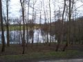
There was a lake on the other side of the road near the hash.


Achievements
Nesk earned the No trespassing consolation prize
|