Difference between revisions of "2012-02-05 33 -117"
imported>Scerruti m (→Participants) |
imported>Scerruti m (→Plans) |
||
| Line 27: | Line 27: | ||
== Plans == | == Plans == | ||
<!-- what were the original plans --> | <!-- what were the original plans --> | ||
| + | Each month my sons and I have a camping trip with our Indian Guides group, the Redhawk Nation. I make a point of checking the hashes for the weekend in case one falls close to our route or near our camp. This weekend Friday's hash fell on our route and Sunday's hash fell just a little off our return route in an area I like to visit. My plans on Sunday were to leave camp, grab a bite to eat (somewhere with a patio because we smell of smoke and a weekend without showers) and then detour to the hash on the way home. | ||
== Expedition == | == Expedition == | ||
Revision as of 00:24, 6 February 2012
| Sun 5 Feb 2012 in 33,-117: 33.0592770, -117.1379030 geohashing.info google osm bing/os kml crox |
Location
This hash is located in a field at the corner of Mount Israel and Detweiler Roads adjacent to the Elfin Forest Recreational Reserve and near Lake Hodges in Escondido, CA. The area is for the most part private homes many with horses.
Participants
scerruti and his son A'
Plans
Each month my sons and I have a camping trip with our Indian Guides group, the Redhawk Nation. I make a point of checking the hashes for the weekend in case one falls close to our route or near our camp. This weekend Friday's hash fell on our route and Sunday's hash fell just a little off our return route in an area I like to visit. My plans on Sunday were to leave camp, grab a bite to eat (somewhere with a patio because we smell of smoke and a weekend without showers) and then detour to the hash on the way home.
Expedition
Tracklog
Photos
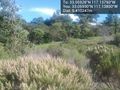
Beautiful spot near Mount Israel recreation Park @33.0593,-117.1380


Achievements