Difference between revisions of "2012-02-29 41 -73"
From Geohashing
imported>NCommander ([live picture] ground zero [http://www.openstreetmap.org/?lat=41.31290976&lon=-73.17942873&zoom=16&layers=B000FTF @41.3129,-73.1794]) |
imported>Jiml m (Add results) |
||
| Line 1: | Line 1: | ||
| − | |||
<!-- If you did not specify these parameters in the template, please substitute appropriate values for IMAGE, LAT, LON, and DATE (YYYY-MM-DD format) | <!-- If you did not specify these parameters in the template, please substitute appropriate values for IMAGE, LAT, LON, and DATE (YYYY-MM-DD format) | ||
| Line 15: | Line 14: | ||
}} | }} | ||
| − | + | ||
__NOTOC__ | __NOTOC__ | ||
== Location == | == Location == | ||
| − | + | North of Bridgeport | |
== Participants == | == Participants == | ||
| − | + | ||
| + | * [[User:NCommander|NCommander]] | ||
== Plans == | == Plans == | ||
| Line 31: | Line 31: | ||
*at the hash point or very close -- [[User:NCommander|NCommander]] [http://www.openstreetmap.org/?lat=41.31293599&lon=-73.17940274&zoom=16&layers=B000FTF @41.3129,-73.1794] 17:47, 29 February 2012 (EST) | *at the hash point or very close -- [[User:NCommander|NCommander]] [http://www.openstreetmap.org/?lat=41.31293599&lon=-73.17940274&zoom=16&layers=B000FTF @41.3129,-73.1794] 17:47, 29 February 2012 (EST) | ||
| + | |||
== Tracklog == | == Tracklog == | ||
<!-- if your GPS device keeps a log, you may post a link here --> | <!-- if your GPS device keeps a log, you may post a link here --> | ||
| Line 60: | Line 61: | ||
[[Category:Expedition planning]] | [[Category:Expedition planning]] | ||
--> | --> | ||
| + | |||
| + | [[Category:Expeditions]] | ||
| + | [[Category:Expeditions with photos]] | ||
| + | |||
<!-- An actual expedition: | <!-- An actual expedition: | ||
Revision as of 23:19, 29 February 2012
| Wed 29 Feb 2012 in 41,-73: 41.3129303, -73.1794689 geohashing.info google osm bing/os kml crox |
Location
North of Bridgeport
Participants
Plans
Expedition
- at the hash point or very close -- NCommander @41.3129,-73.1794 17:47, 29 February 2012 (EST)
Tracklog
Photos
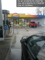
fueling @40.9181,-73.7751
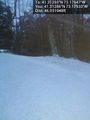
Hash point from the road. Approx 5 to 10 feet @41.3129,-73.1793
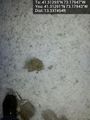
ground zero @41.3129,-73.1794


Achievements