Difference between revisions of "2012-02-29 42 -71"
imported>Phyzome (planning: woods, driveway) |
m |
||
| (6 intermediate revisions by 2 users not shown) | |||
| Line 1: | Line 1: | ||
| − | |||
| − | |||
| − | |||
| − | |||
| − | |||
| − | |||
| − | |||
| − | |||
| − | |||
{{meetup graticule | {{meetup graticule | ||
| lat=42 | | lat=42 | ||
| Line 13: | Line 4: | ||
| date=2012-02-29 | | date=2012-02-29 | ||
}} | }} | ||
| − | + | Failed hash in Newton, MA. | |
| − | |||
__NOTOC__ | __NOTOC__ | ||
== Location == | == Location == | ||
| Line 30: | Line 20: | ||
== Expedition == | == Expedition == | ||
| − | |||
| − | + | Phyzome: | |
| − | + | ||
| + | I left work at around 16:45 EST (dusk), taking the Red Line to Park Street, then the Green Line (D/Riverside) out to Brookline Hills. My planning was kind of terrible, so my photos of Google Maps (which I use in lieu of a proper streetmap-integrated GPS) did not include how to get from the T station to bus 60. By the time I figured it out (using a map I still had loaded in my browser on my laptop) I had just missed the bus, and had to wait for about 20 minutes. The bus dropped me off in some commercial mall-hell thingy, and I wandered down to "Boylston St", which is a highway in its own right at that point, and started west. My old, crappy GPS didn't see much in the way of satellites, but I knew my turn-off to the south was Dudley Rd. | ||
| + | |||
| + | As I walked west, I noted the fence running down the middle of the divided highway. I really should have paid more attention to that. I only encountered one crossing, halfway to Dudley Rd... *including* Dudley Rd. Oops! Backtrack, cross, walk west again. Finally. | ||
| + | |||
| + | The second photo of the gallery is there to commemorate my learning two lessons: | ||
| + | |||
| + | # Cross highways as soon as possible, you may not get another chance | ||
| + | # Dial down the flash when photographing retroreflective materials | ||
| + | |||
| + | Dudley Road had some pretty fancy houses on it. I must have looked pretty out of place, walking at night in the snow along the road. I finally found the field I had forgotten to look for and wandered up the shared driveway... and damn, rhododendrons. A big pile of them, covered in snow, at night, in front of someone's house. I wasn't going to stomp around, breaking plants and getting covered in slush and maybe freaking someone out, so I called it a night and trudged back the way I had come. And you know? It was really pretty out, with the light snowfall -- I hadn't noticed so much on the way to the hashpoint. | ||
| + | |||
| + | The walk back to the bus was uneventful, other than seeing it leave about a minute before I got to the stop. Sigh. Another 30 minute wait. I've posted a photo of fliers attached to the bus stop signpost -- the MBTA is threatening fare hikes (annoying) and service cuts (bad!) due to budget shortfalls. This bus route might get eliminated entirely! Ew. | ||
| + | |||
| + | Bus 60 to Kenmore, Green Line, Red Line, walk home. 21:30 EST. Even though I didn't reach the point, I'm glad that I attempted it. It has been a while, and the new surroundings were a refreshing change. | ||
== Photos == | == Photos == | ||
| − | |||
| − | |||
| − | |||
<gallery perrow="5"> | <gallery perrow="5"> | ||
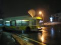
| + | Image:2012-02-29 42 -71 waiting for bus.jpg | Waiting for the bus | ||
| + | Image:2012-02-29 42 -71 hasher-proof fence.jpg | Hasher-Proof Fence (2 lessons learned) | ||
| + | Image:2012-02-29 42 -71 rhodo-blocked.jpg | Rhodo-blocked | ||
| + | Image:2012-02-29 42 -71 no trespassing.jpg | And "no trespassing" | ||
| + | Image:2012-02-29 42 -71 circumnavigation.jpg | Not making it: The tracklog edition | ||
| + | Image:2012-02-29 42 -71 but it snowed.jpg | At least it was snowing | ||
| + | Image:2012-02-29 42 -71 noooooo.jpg | Stupid sneaky bus | ||
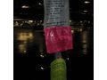
| + | Image:2012-02-29 42 -71 save the bus routes.jpg | Should I write in about the expedition? :-P | ||
</gallery> | </gallery> | ||
| − | |||
| − | |||
| − | |||
| − | |||
| − | |||
| − | |||
| − | |||
| − | |||
[[Category:Expeditions]] | [[Category:Expeditions]] | ||
| − | |||
[[Category:Expeditions with photos]] | [[Category:Expeditions with photos]] | ||
| − | |||
| − | |||
| − | |||
| − | |||
| − | |||
| − | |||
| − | |||
| − | |||
| − | |||
[[Category:Coordinates not reached]] | [[Category:Coordinates not reached]] | ||
| − | + | [[Category:Not reached - No public access]] | |
| − | + | {{location|US|MA|MI}} | |
| − | [[Category:Not reached - No public access]] | ||
| − | |||
| − | |||
| − | |||
Latest revision as of 12:51, 21 April 2022
| Wed 29 Feb 2012 in 42,-71: 42.3129303, -71.1794689 geohashing.info google osm bing/os kml crox |
Failed hash in Newton, MA.
Location
- Probably on someone's driveway
- Near Lost Pond Reservation
- Border of Newton, MA and Brookline, MA
Participants
- Phyzome plans to attend -- poke on IRC or userpage to coordinate!
Plans
- Phyzome: I plan on taking the Green Line out after work, maybe starting around 4:30. I'll either walk from there or take bus 60 to get closer. If I walk through the woods, I can shave 0.7 miles off the walk from the Green Line. Will bring chocolate.
Expedition
Phyzome:
I left work at around 16:45 EST (dusk), taking the Red Line to Park Street, then the Green Line (D/Riverside) out to Brookline Hills. My planning was kind of terrible, so my photos of Google Maps (which I use in lieu of a proper streetmap-integrated GPS) did not include how to get from the T station to bus 60. By the time I figured it out (using a map I still had loaded in my browser on my laptop) I had just missed the bus, and had to wait for about 20 minutes. The bus dropped me off in some commercial mall-hell thingy, and I wandered down to "Boylston St", which is a highway in its own right at that point, and started west. My old, crappy GPS didn't see much in the way of satellites, but I knew my turn-off to the south was Dudley Rd.
As I walked west, I noted the fence running down the middle of the divided highway. I really should have paid more attention to that. I only encountered one crossing, halfway to Dudley Rd... *including* Dudley Rd. Oops! Backtrack, cross, walk west again. Finally.
The second photo of the gallery is there to commemorate my learning two lessons:
- Cross highways as soon as possible, you may not get another chance
- Dial down the flash when photographing retroreflective materials
Dudley Road had some pretty fancy houses on it. I must have looked pretty out of place, walking at night in the snow along the road. I finally found the field I had forgotten to look for and wandered up the shared driveway... and damn, rhododendrons. A big pile of them, covered in snow, at night, in front of someone's house. I wasn't going to stomp around, breaking plants and getting covered in slush and maybe freaking someone out, so I called it a night and trudged back the way I had come. And you know? It was really pretty out, with the light snowfall -- I hadn't noticed so much on the way to the hashpoint.
The walk back to the bus was uneventful, other than seeing it leave about a minute before I got to the stop. Sigh. Another 30 minute wait. I've posted a photo of fliers attached to the bus stop signpost -- the MBTA is threatening fare hikes (annoying) and service cuts (bad!) due to budget shortfalls. This bus route might get eliminated entirely! Ew.
Bus 60 to Kenmore, Green Line, Red Line, walk home. 21:30 EST. Even though I didn't reach the point, I'm glad that I attempted it. It has been a while, and the new surroundings were a refreshing change.
Photos
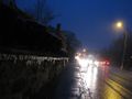
Waiting for the bus
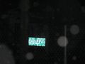
Hasher-Proof Fence (2 lessons learned)
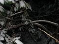
Rhodo-blocked
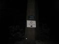
And "no trespassing"
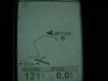
Not making it: The tracklog edition
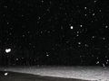
At least it was snowing
Stupid sneaky bus
Should I write in about the expedition? :-P


