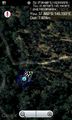
2012-03-18 -37 145
| Sun 18 Mar 2012 in -37,145: -37.8819343, 145.1932346 geohashing.info google osm bing/os kml crox |
Location
Participants
- Kozz
- myka
- ez
Plans
Myka and Ez will be heading out after lunch, to have a look around
Expedition #1
- On my way out to the park now. Kozz 18:53, 17 March 2012 (EDT) -- Kozz 09:53, 18 March 2012 (GMT+11:00)
Expedition #2
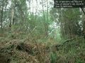
Apparently there were two expeditions! Oops. Felix Dance and Stevage cycled there, arriving around 4:45pm. Taking a navigationally suboptimal route, we found ourselves on the wrong side of the creek. Probably the most efficient thing to do would be to ride to the nearest bridge and back. Instead, we availed ourselves of a fallen log suspended over the creek.
Foolishly I couldn't find my GPS and had to rely on my phone. It said the point was basically right on the path. Felix's GPS didn't really settle down and seemed to be pointing into the bushes. We shrugged, took our photos, and headed back over the log of doom.
Tracklog
Photos
Expedition #1
Reached!
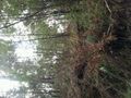
Hashpoint location
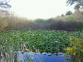
Ponds nearby
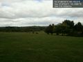
Arrived at Norton park. The hash is down that way @-37.8792,145.1988
Retreating kozz' the hash photo @-37.8820,145.1930


Expedition #2


Achievements