Difference between revisions of "2012-04-06 41 -88"
imported>RocketMac (Created page with "{{Subst:Expedition | lat = 41 | lon = -88 | date = 2012-04-06 }}") |
imported>RocketMac |
||
| Line 1: | Line 1: | ||
| − | |||
| − | |||
| − | |||
| − | |||
| − | |||
| − | |||
| − | |||
| − | |||
| − | |||
| − | |||
{{meetup graticule | {{meetup graticule | ||
| lat=41 | | lat=41 | ||
| Line 15: | Line 5: | ||
}} | }} | ||
| − | |||
| − | |||
== Location == | == Location == | ||
| − | + | Side of a road in rural Illinois on my way home from St. Louis. | |
== Participants == | == Participants == | ||
| − | + | * [[User:RocketMac|RocketMac]] | |
== Plans == | == Plans == | ||
| − | + | When the class I was teaching this week started winding own, I checked for any reachable hashpoints on my drive from [[38,-90|St. Louis] to [[42.-88|Milwaukee]] and found that the [[41,-88]] graticule would only add less than an hour to my drive and mark off another notch on my [[Minesweeper Geohash|Minesweeper]] badge. | |
== Expedition == | == Expedition == | ||
| − | + | Originally I had anticipated being done with class and on the road by 2pm, but due to some technical difficulties and some good solid questions from one of the students, I didn't hit the road until almost 4pm. So by the time I made the hashpoint, it was after 9pm and dark. | |
| + | |||
| + | From the moment I left 55, I was subjected to a lot of 30-45mph zones and a '''lot''' of red light clusters I hit wrong every time. Normally with geohashing, I find these "scenic" detours to be the main point. But after dark, it's just slow going. | ||
== Tracklog == | == Tracklog == | ||
| − | <!-- | + | <!--My tracklog is available in [http://coldshadow.com/geohashing/2012-04-06.gpx GPX] and [http://coldshadow.com/geohashing/2012-04-06.kmz KMZ] formats.--> |
| + | ''Coming Soon'' | ||
== Photos == | == Photos == | ||
| − | |||
| − | |||
| − | |||
<gallery perrow="5"> | <gallery perrow="5"> | ||
| + | Image:RocketMac 2012-04-06 41 -88 01.jpg | Farmhouse from the hashpoint | ||
| + | Image:RocketMac 2012-04-06 41 -88 02.jpg | Stupid (Blurry) Grin | ||
| + | Image:RocketMac 2012-04-06 41 -88 03.jpg | GPS Capture | ||
</gallery> | </gallery> | ||
== Achievements == | == Achievements == | ||
{{#vardefine:ribbonwidth|800px}} | {{#vardefine:ribbonwidth|800px}} | ||
| − | + | {{land geohash | |
| + | | latitude = 41 | ||
| + | | longitude = -88 | ||
| + | | date = 2012-04-06 | ||
| + | | name = RocketMac | ||
| + | | image = | ||
| + | }} | ||
| + | {{Minesweeper geohash | ||
| + | | graticule = Schaumburg, Illinois | ||
| + | | ranknumber = 6 | ||
| + | | n = true | ||
| + | | ne = true | ||
| + | | e = true | ||
| + | | se = true | ||
| + | | s = true | ||
| + | | sw = | ||
| + | | w = | ||
| + | | nw = true | ||
| + | | name = RocketMac | ||
| + | }} | ||
<!-- =============== USEFUL CATEGORIES FOLLOW ================ | <!-- =============== USEFUL CATEGORIES FOLLOW ================ | ||
| − | |||
[[Category:New report]] | [[Category:New report]] | ||
| − | |||
| − | |||
| − | |||
| − | |||
| − | |||
| − | |||
[[Category:Expeditions]] | [[Category:Expeditions]] | ||
| − | |||
[[Category:Expeditions with photos]] | [[Category:Expeditions with photos]] | ||
| − | |||
| − | |||
| − | |||
| − | |||
| − | |||
[[Category:Coordinates reached]] | [[Category:Coordinates reached]] | ||
| − | |||
| − | |||
| − | |||
| − | |||
| − | |||
| − | |||
| − | |||
| − | |||
| − | |||
| − | |||
Revision as of 22:23, 7 April 2012
| Fri 6 Apr 2012 in 41,-88: 41.8083156, -88.5005609 geohashing.info google osm bing/os kml crox |
Location
Side of a road in rural Illinois on my way home from St. Louis.
Participants
Plans
When the class I was teaching this week started winding own, I checked for any reachable hashpoints on my drive from [[38,-90|St. Louis] to Milwaukee and found that the 41,-88 graticule would only add less than an hour to my drive and mark off another notch on my Minesweeper badge.
Expedition
Originally I had anticipated being done with class and on the road by 2pm, but due to some technical difficulties and some good solid questions from one of the students, I didn't hit the road until almost 4pm. So by the time I made the hashpoint, it was after 9pm and dark.
From the moment I left 55, I was subjected to a lot of 30-45mph zones and a lot of red light clusters I hit wrong every time. Normally with geohashing, I find these "scenic" detours to be the main point. But after dark, it's just slow going.
Tracklog
Coming Soon
Photos
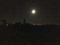
Farmhouse from the hashpoint

Stupid (Blurry) Grin
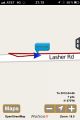
GPS Capture


Achievements
RocketMac earned the Land geohash achievement
|
RocketMac achieved level 6 of the Minesweeper Geohash achievement
|