Difference between revisions of "2012-04-21 33 -118"
imported>JesseW (Created page with "{{subst:Expedition |lat = 33 |lon = -118 |date = 2012-04-21 }}") |
m (→Photos: +img) |
||
| (3 intermediate revisions by 2 users not shown) | |||
| Line 1: | Line 1: | ||
| − | |||
| − | |||
| − | |||
| − | |||
| − | |||
{{meetup graticule | {{meetup graticule | ||
| lat=33 | | lat=33 | ||
| Line 10: | Line 5: | ||
}} | }} | ||
| − | |||
__NOTOC__ | __NOTOC__ | ||
== Location == | == Location == | ||
| − | + | Inside the 6900 Orange Ave. [[wikipedia:Southern California Edison|Southern California Edison]] substation. | |
== Participants == | == Participants == | ||
| − | + | * [[User:JesseW|JesseW]] | |
| − | |||
== Plans == | == Plans == | ||
<!-- what were the original plans --> | <!-- what were the original plans --> | ||
| + | Drive to the street nearest the hashpoint, and look around, take photos. I expected not to be able to make it all the way to the coordinates, due to HIGH VOLTAGE issues. | ||
== Expedition == | == Expedition == | ||
<!-- how it all turned out. your narrative goes here. --> | <!-- how it all turned out. your narrative goes here. --> | ||
| + | This was my first ever geohash, so I didn't know what to expect (and I took a lot of photos). I was only in LA for the weekend, and the house I was staying in was about 40 minutes away from the hashpoint by car. | ||
| − | + | I arrived just before dark, at around 7:30 PM. I drove past the closest point I could reach by car, parked, and walked back, snapping photos of the substation, the (many) Danger and No Trespassing signs, and the wires overhead as I went. I had lots of problems with the camera being out of focus due to the long exposure times needed due to the evening light. | |
| − | + | ||
| + | I lacked a GPS unit, so I relied on a printout of the satellite image to pinpoint what I thought was the closest point along the fence to the coordinates. Once I reached there, I tried (somewhat unsuccessfully) to get a close-up image of the point, but managed to get some pictures of me (in [[Formal attire achievement|formal attire]]). | ||
| + | |||
| + | There was a Mormon temple directly across the street, with some nice Art Deco ornamentation. | ||
| + | |||
| + | == Photos == | ||
| − | |||
| − | |||
| − | |||
| − | |||
<gallery perrow="5"> | <gallery perrow="5"> | ||
| + | 2012-04-21 33 -118 01 Turning onto Orange Ave.jpg | Turning onto Orange Ave. from Artesia Blvd. | ||
| + | 2012-04-21 33 -118 02 Substation sign.jpg | The sign for the substation. | ||
| + | 2012-04-21 33 -118 03 View into the substation.jpg | The view (including a satellite dish) as I was walking alongside the substation | ||
| + | 2012-04-21 33 -118 04 Warning signs.jpg | The top sign was repeated numerous times along the fence. | ||
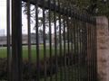
| + | 2012-04-21 33 -118 05 Directly opposite the hashpoint.jpg | This is as close as I got. I think the hashpoint is next to the round dial in the middle of the image (zoom in). | ||
| + | 2012-04-21 33 -118 06 Me with Stupid Grin.jpg | Requisite Stupid Grin (TM), in formal attire (unfortunately lacking a tie, so no ribbon for me). | ||
| + | 2012-04-21 33 -118 07 Lines running into the substation.jpg | It was a big substation, with many power lines entering it. | ||
| + | 2012-04-21 33 -118 09 Mormon temple.jpg | Nice Art Deco columns. | ||
| + | 2012-04-21 33 -118 10 Mormon temple sign.jpg | The sign for the Art Deco Mormon temple | ||
| + | temple.JPG | distant | ||
</gallery> | </gallery> | ||
| Line 38: | Line 44: | ||
{{#vardefine:ribbonwidth|800px}} | {{#vardefine:ribbonwidth|800px}} | ||
<!-- Add any achievement ribbons you earned below, or remove this section --> | <!-- Add any achievement ribbons you earned below, or remove this section --> | ||
| + | {{No trespassing | ||
| + | | latitude = 33 | ||
| + | | longitude = -118 | ||
| + | | date = 2012-04-21 | ||
| + | | name = [[User:JesseW|JesseW]] | ||
| + | | image = 2012-04-21 33 -118 04 Warning signs.jpg | ||
| + | }} | ||
| − | |||
| − | |||
| − | |||
| − | |||
| − | |||
| − | |||
| − | |||
| − | |||
| − | |||
| − | |||
| − | |||
[[Category:Expeditions]] | [[Category:Expeditions]] | ||
| − | |||
[[Category:Expeditions with photos]] | [[Category:Expeditions with photos]] | ||
| − | |||
[[Category:Expedition without GPS]] | [[Category:Expedition without GPS]] | ||
| − | |||
| − | |||
| − | |||
| − | |||
| − | |||
| − | |||
[[Category:Coordinates not reached]] | [[Category:Coordinates not reached]] | ||
| − | + | [[Category:Not reached - No public access]] | |
| − | + | {{location|US|CA|LO}} | |
| − | [[Category:Not reached - No public access]] | ||
| − | |||
| − | |||
| − | |||
Latest revision as of 07:06, 19 May 2022
| Sat 21 Apr 2012 in 33,-118: 33.8800045, -118.1758045 geohashing.info google osm bing/os kml crox |
Location
Inside the 6900 Orange Ave. Southern California Edison substation.
Participants
Plans
Drive to the street nearest the hashpoint, and look around, take photos. I expected not to be able to make it all the way to the coordinates, due to HIGH VOLTAGE issues.
Expedition
This was my first ever geohash, so I didn't know what to expect (and I took a lot of photos). I was only in LA for the weekend, and the house I was staying in was about 40 minutes away from the hashpoint by car.
I arrived just before dark, at around 7:30 PM. I drove past the closest point I could reach by car, parked, and walked back, snapping photos of the substation, the (many) Danger and No Trespassing signs, and the wires overhead as I went. I had lots of problems with the camera being out of focus due to the long exposure times needed due to the evening light.
I lacked a GPS unit, so I relied on a printout of the satellite image to pinpoint what I thought was the closest point along the fence to the coordinates. Once I reached there, I tried (somewhat unsuccessfully) to get a close-up image of the point, but managed to get some pictures of me (in formal attire).
There was a Mormon temple directly across the street, with some nice Art Deco ornamentation.
Photos
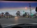
Turning onto Orange Ave. from Artesia Blvd.
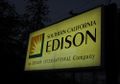
The sign for the substation.
The view (including a satellite dish) as I was walking alongside the substation
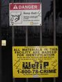
The top sign was repeated numerous times along the fence.
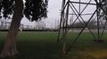
This is as close as I got. I think the hashpoint is next to the round dial in the middle of the image (zoom in).
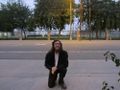
Requisite Stupid Grin (TM), in formal attire (unfortunately lacking a tie, so no ribbon for me).
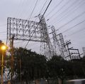
It was a big substation, with many power lines entering it.
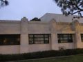
Nice Art Deco columns.
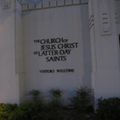
The sign for the Art Deco Mormon temple
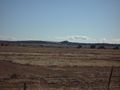
distant


Achievements
JesseW earned the No trespassing consolation prize
|