Difference between revisions of "2012-04-29 53 6"
imported>Elwingelfje |
imported>FippeBot m (Location) |
||
| (18 intermediate revisions by 2 users not shown) | |||
| Line 1: | Line 1: | ||
| − | |||
| − | |||
| − | |||
| − | |||
{{meetup graticule | {{meetup graticule | ||
| lat=53 | | lat=53 | ||
| Line 9: | Line 5: | ||
}} | }} | ||
| − | + | ||
__NOTOC__ | __NOTOC__ | ||
== Location == | == Location == | ||
| − | + | Lauwersmeer, a nature area close to the village of Lauwersmeer. The actual hash is a few meters away from a path. | |
== Participants == | == Participants == | ||
| − | + | * [[User:Elwingelfje|Elwingelfje]] | |
| − | |||
== Plans == | == Plans == | ||
| − | + | Go to Lauwersoog by car (I don't even know if you can get there by bus) and then take a walk towards the hash. Also, walk on the dike. | |
== Expedition == | == Expedition == | ||
| − | + | I drove from Groningen up to the port of Lauwersoog, where I parked my car. The idea | |
| + | was to continue from there to the hashpoint on foot. Quite feasible. | ||
| + | |||
| + | There were a lot of sheep on the dike, some of them walking with me for a while. | ||
| + | When studying the maps I had wondered why the forest there had so many paths. | ||
| + | Coming closer, I realized why: the hashpoint was in the middle of a military | ||
| + | practice terrain, mainly used for shooting exercises. | ||
| + | |||
| + | I'll admit it was not | ||
| + | forbidden to access. However, on the way there I encountered signs of an | ||
| + | increasingly alarming nature (and photographed a few of them). Most of them had a | ||
| + | message something like: "Hey, did you know this is military terrain? Oh, that doesn't | ||
| + | mean you can't enter; do so by any means. But maybe it's good to know that we shoot | ||
| + | here on a regular basis, with bullets, and if you're here at the wrong time you might | ||
| + | just get hit. That time is not now. You might find the bullets though. Don't pick them | ||
| + | up, for it could kill you." | ||
| − | == | + | For a while I trudged on, along an asphalt road. Then a |
| − | + | bicycle path curved off into the forest, which I followed. I had to turn left at an | |
| + | (opened) fence and the largest and most-menacing looking sign yet, warning me to | ||
| + | approach under no circumstance the buildings in this area (though it wasn't forbidden to go on). | ||
| + | |||
| + | Here I didn't really dare to go on as I was afraid it was not allowed after all in some way, | ||
| + | and I was a little scared of getting shot or exploding on a hidden landmine. Also I was a | ||
| + | bit pressed for time as I still had to work in the afternoon. I walked back through a nice | ||
| + | green forested area and passed a really cool wooden pedestrian bridge over the highway. I | ||
| + | came back to my car and ate some lunch on a picnic bench next to a playground, then left | ||
| + | for work. | ||
| + | |||
| + | == Epilogue == | ||
| + | I enjoyed it a lot and I think I'll be geohashing soon again! | ||
== Photos == | == Photos == | ||
| − | < | + | |
| − | Image: | + | <gallery perrow="6"> |
| − | -- | + | Image:2012-04-29_53_6_signs_2.JPG | First batch of signs. Front one: "Ministry of Defense. Private road, access at your own risk." Back one is a sign stating on which days there will be shooting exercises. |
| − | + | Image:2012-04-29 53 6 signs.jpg | The signs that made me turn back at last. The image quality is not the best but the upper one says: 'Shooting terrain - the terrain behind this sign is extremely dangerous because of shooting exercises when a red flag or lamp has been placed on the sign' (notice the absence of lamp or flag). The lower one says: 'Warning! On this terrain you may find the remains of munition. Picking this up may place you in danger and is therefore forbidden.' | |
| + | Image:2012-04-29 53 6 pedestrian bridge.jpg | Cool bridge! I love this | ||
| + | Image:2012-04-29 53 6 me bridge.jpg | Me on the bridge | ||
| + | Image:2012-04-29 53 6 me forest.jpg | And me in the forest | ||
| + | Image:2012-04-29 53 6 mailbox.jpg | Mailbox that I encountered on the way back, I've never seen this type before. | ||
</gallery> | </gallery> | ||
== Achievements == | == Achievements == | ||
| + | |||
{{#vardefine:ribbonwidth|800px}} | {{#vardefine:ribbonwidth|800px}} | ||
| − | + | {{Prize poultry | |
| + | |||
| + | | latitude = 53 | ||
| + | | longitude = 6 | ||
| + | | date = 2012-04-29 | ||
| + | | name = [[User:elwingelfje|elwingelfje]] | ||
| + | | reason = of threatening-looking signs of a military nature | ||
| + | }} | ||
| + | |||
| − | |||
| − | |||
| − | |||
| − | |||
| − | |||
| − | |||
| − | |||
| − | |||
[[Category:Expeditions]] | [[Category:Expeditions]] | ||
| − | |||
[[Category:Expeditions with photos]] | [[Category:Expeditions with photos]] | ||
| − | |||
[[Category:Expedition without GPS]] | [[Category:Expedition without GPS]] | ||
| − | |||
| − | |||
| − | |||
| − | |||
| − | |||
| − | |||
| − | |||
[[Category:Coordinates not reached]] | [[Category:Coordinates not reached]] | ||
| − | + | [[Category:Not reached - Time constraints]] | |
| − | + | {{location|NL|GR}} | |
| − | |||
| − | [[Category:Not reached - | ||
| − | |||
| − | |||
Latest revision as of 03:43, 13 August 2019
| Sun 29 Apr 2012 in 53,6: 53.4091492, 6.2376230 geohashing.info google osm bing/os kml crox |
Location
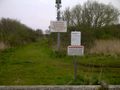
Lauwersmeer, a nature area close to the village of Lauwersmeer. The actual hash is a few meters away from a path.
Participants
Plans
Go to Lauwersoog by car (I don't even know if you can get there by bus) and then take a walk towards the hash. Also, walk on the dike.
Expedition
I drove from Groningen up to the port of Lauwersoog, where I parked my car. The idea was to continue from there to the hashpoint on foot. Quite feasible.
There were a lot of sheep on the dike, some of them walking with me for a while. When studying the maps I had wondered why the forest there had so many paths. Coming closer, I realized why: the hashpoint was in the middle of a military practice terrain, mainly used for shooting exercises.
I'll admit it was not forbidden to access. However, on the way there I encountered signs of an increasingly alarming nature (and photographed a few of them). Most of them had a message something like: "Hey, did you know this is military terrain? Oh, that doesn't mean you can't enter; do so by any means. But maybe it's good to know that we shoot here on a regular basis, with bullets, and if you're here at the wrong time you might just get hit. That time is not now. You might find the bullets though. Don't pick them up, for it could kill you."
For a while I trudged on, along an asphalt road. Then a bicycle path curved off into the forest, which I followed. I had to turn left at an (opened) fence and the largest and most-menacing looking sign yet, warning me to approach under no circumstance the buildings in this area (though it wasn't forbidden to go on).
Here I didn't really dare to go on as I was afraid it was not allowed after all in some way, and I was a little scared of getting shot or exploding on a hidden landmine. Also I was a bit pressed for time as I still had to work in the afternoon. I walked back through a nice green forested area and passed a really cool wooden pedestrian bridge over the highway. I came back to my car and ate some lunch on a picnic bench next to a playground, then left for work.
Epilogue
I enjoyed it a lot and I think I'll be geohashing soon again!
Photos
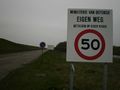
First batch of signs. Front one: "Ministry of Defense. Private road, access at your own risk." Back one is a sign stating on which days there will be shooting exercises.
The signs that made me turn back at last. The image quality is not the best but the upper one says: 'Shooting terrain - the terrain behind this sign is extremely dangerous because of shooting exercises when a red flag or lamp has been placed on the sign' (notice the absence of lamp or flag). The lower one says: 'Warning! On this terrain you may find the remains of munition. Picking this up may place you in danger and is therefore forbidden.'
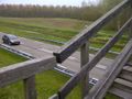
Cool bridge! I love this

Me on the bridge

And me in the forest
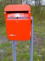
Mailbox that I encountered on the way back, I've never seen this type before.


Achievements
elwingelfje earned the Prize poultry Consolation Prize
|