Difference between revisions of "2012-05-16 38 -121"
imported>Chandru (→Achievements) |
imported>FippeBot m (Location) |
||
| (4 intermediate revisions by 2 users not shown) | |||
| Line 1: | Line 1: | ||
| − | |||
| − | |||
| − | |||
| − | |||
{{meetup graticule | {{meetup graticule | ||
| lat = 38 | | lat = 38 | ||
| Line 9: | Line 5: | ||
}} | }} | ||
| − | |||
__NOTOC__ | __NOTOC__ | ||
== Location == | == Location == | ||
| − | |||
Intersection of Sievers Road and Granett Lane. If you were to draw a diagonal line between Dixon and Winters, this is in the center, though Google tells me it's in the city of Winters. Also approximately 13 miles southwest of Davis. | Intersection of Sievers Road and Granett Lane. If you were to draw a diagonal line between Dixon and Winters, this is in the center, though Google tells me it's in the city of Winters. Also approximately 13 miles southwest of Davis. | ||
== Participants == | == Participants == | ||
| − | |||
| − | |||
[[User:Chandru|Chandru]] | [[User:Chandru|Chandru]] | ||
| + | |||
== Plans == | == Plans == | ||
| − | |||
To tell the truth, I had no plans coming in. I have been following this site for a while, but have never been up for biking to Lodi (I'm not good enough to bike 100+ miles in one stretch). This was the closest one that I've seen for a while, so I decided to go for it! | To tell the truth, I had no plans coming in. I have been following this site for a while, but have never been up for biking to Lodi (I'm not good enough to bike 100+ miles in one stretch). This was the closest one that I've seen for a while, so I decided to go for it! | ||
== Expedition == | == Expedition == | ||
| − | |||
I left UC Davis heading west on Russell Blvd. I was able to utilize the nice bike path on Russell between Davis and Winters. | I left UC Davis heading west on Russell Blvd. I was able to utilize the nice bike path on Russell between Davis and Winters. | ||
| Line 31: | Line 22: | ||
Granett Lane is a small dirt road that leads to a farm. The location was technically a few hundred meters west of the road, but that was behind one of the farm buildings, a place that I did not want to go. | Granett Lane is a small dirt road that leads to a farm. The location was technically a few hundred meters west of the road, but that was behind one of the farm buildings, a place that I did not want to go. | ||
| − | |||
| − | |||
== Photos == | == Photos == | ||
| − | |||
| − | |||
| − | |||
<gallery perrow="5"> | <gallery perrow="5"> | ||
Image:IMG_20120516_180026.jpg|View from Granett Lane looking east. Just fields. | Image:IMG_20120516_180026.jpg|View from Granett Lane looking east. Just fields. | ||
| Line 49: | Line 35: | ||
== Achievements == | == Achievements == | ||
{{#vardefine:ribbonwidth|800px}} | {{#vardefine:ribbonwidth|800px}} | ||
| − | <!-- | + | <!-- This really looks more like a No Trespassing than a Coordinates Reached... I'm changing the page to reflect that, unless someone can make a convincing argument why I shouldn't. |
{{land geohash | {{land geohash | ||
| latitude = 38 | | latitude = 38 | ||
| Line 66: | Line 52: | ||
| image = IMG_20120516_180033.jpg | | image = IMG_20120516_180033.jpg | ||
}} | }} | ||
| − | |||
| − | |||
| − | |||
| − | |||
| − | |||
| − | |||
| − | |||
| − | |||
--> | --> | ||
| + | {{No trespassing|latitude=38|longitude=-121|date=2012-05-16|name=[[User:Chandru|Chandru]]}} | ||
| − | |||
[[Category:Expeditions]] | [[Category:Expeditions]] | ||
| − | |||
[[Category:Expeditions with photos]] | [[Category:Expeditions with photos]] | ||
| − | |||
| − | |||
| − | |||
| − | |||
| − | |||
| − | |||
| − | |||
| − | |||
| − | |||
[[Category:Coordinates not reached]] | [[Category:Coordinates not reached]] | ||
| − | + | [[Category:Not reached - No public access]] | |
| − | + | {{location|US|CA|SN}} | |
| − | [[Category:Not reached - No public access]] | ||
| − | |||
| − | |||
| − | |||
Latest revision as of 04:02, 13 August 2019
| Wed 16 May 2012 in 38,-121: 38.4955438, -121.9011109 geohashing.info google osm bing/os kml crox |
Location
Intersection of Sievers Road and Granett Lane. If you were to draw a diagonal line between Dixon and Winters, this is in the center, though Google tells me it's in the city of Winters. Also approximately 13 miles southwest of Davis.
Participants
Plans
To tell the truth, I had no plans coming in. I have been following this site for a while, but have never been up for biking to Lodi (I'm not good enough to bike 100+ miles in one stretch). This was the closest one that I've seen for a while, so I decided to go for it!
Expedition
I left UC Davis heading west on Russell Blvd. I was able to utilize the nice bike path on Russell between Davis and Winters.
I turned left on County Road 95A. I crossed Stevenson Bridge (aka Graffiti Bridge) across Putah Creek and into Solano County and Stevenson Bridge Road. While continuing on Stevenson Bridge Road, I passed by the Wednesday Night Time Trials.
When Stevenson Bridge Road ended I turned right on Sievers Road. Then I stayed on that road until I hit Granett Lane.
Granett Lane is a small dirt road that leads to a farm. The location was technically a few hundred meters west of the road, but that was behind one of the farm buildings, a place that I did not want to go.
Photos
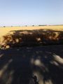
View from Granett Lane looking east. Just fields.
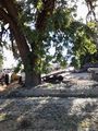
The actual location is behind this. Looks like private property so I didn't go.
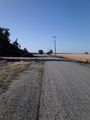
Looking north on Granett. There seems to be little more on this road than a house.
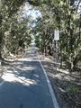
The Davis-Winters bike path.
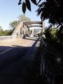
Stevenson Creek Bridge. I crossed the county line here apparently, but I have no idea when I crossed back from Solano County to Yolo County, as the farm is apparently in Winters.


Achievements
Chandru earned the No trespassing consolation prize
|