Difference between revisions of "2012-05-17 59 19"
From Geohashing
imported>Cjk (View of the hash [http://www.openstreetmap.org/?lat=59.74890000&lon=19.02420000&zoom=16&layers=B000FTF @59.7489,19.0242]) |
imported>Cjk ([http://www.openstreetmap.org/?lat=59.74890000&lon=19.02420000&zoom=16&layers=B000FTF @59.7489,19.0242]) |
||
| Line 59: | Line 59: | ||
Image:2012-05-17_59_19_20-06-16-628.jpg | View of the hash [http://www.openstreetmap.org/?lat=59.74890000&lon=19.02420000&zoom=16&layers=B000FTF @59.7489,19.0242] | Image:2012-05-17_59_19_20-06-16-628.jpg | View of the hash [http://www.openstreetmap.org/?lat=59.74890000&lon=19.02420000&zoom=16&layers=B000FTF @59.7489,19.0242] | ||
| + | |||
| + | Image:2012-05-17_59_19_20-06-35-548.jpg | [http://www.openstreetmap.org/?lat=59.74890000&lon=19.02420000&zoom=16&layers=B000FTF @59.7489,19.0242] | ||
</gallery> | </gallery> | ||
Revision as of 18:06, 17 May 2012
| Thu 17 May 2012 in 59,19: 59.7491023, 19.0242625 geohashing.info google osm bing/os kml crox |
Location
In a field 10 miles east of Norrtälje, Sweden.
Participants
Plans
- As tomorrow is Ascension Day which is a public holiday in Sweden, I have the day off. I will drive up there around noon. -- Per S
- I'll leave in my car from Stockholm around noon -- Cjk 05:37, 17 May 2012 (EDT)
Expedition
- Försten dit! -- Per S 15:43, 16 May 2012 (CEST)
- I'll be there! -- Cjk 16:16, 16 May 2012 (CEST)
- Made it. Deflowered. -- Cjk @59.7491,19.0243 13:47, 17 May 2012 (CEST)
Tracklog
Photos
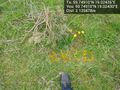
Orange @59.7491,19.0243

Ready to take off.

TheFashionStatement
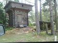
Structure and boat looked almost Viking.
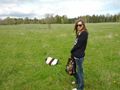
TheFashionStatement at the hash.

Russian Circles
Hashtree @59.7489,19.0242
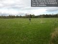
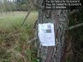
View of the hash @59.7489,19.0242


Achievements