Difference between revisions of "2012-05-22 32 -116"
From Geohashing
imported>LucasBrown ([live picture] Geohash Droid screenshot at the hashpoint---satellite view [http://www.openstreetmap.org/?lat=32.94321946&lon=-116.95479327&zoom=16&layers=B000FTF @32.9432,-116.9548]) |
imported>LucasBrown ([live picture] The hashpoint [http://www.openstreetmap.org/?lat=32.94322578&lon=-116.95480404&zoom=16&layers=B000FTF @32.9432,-116.9548]) |
||
| Line 37: | Line 37: | ||
Image:2012-05-22_32_-116_15-17-32-893.jpg | Geohash Droid screenshot at the hashpoint---satellite view [http://www.openstreetmap.org/?lat=32.94321946&lon=-116.95479327&zoom=16&layers=B000FTF @32.9432,-116.9548] | Image:2012-05-22_32_-116_15-17-32-893.jpg | Geohash Droid screenshot at the hashpoint---satellite view [http://www.openstreetmap.org/?lat=32.94321946&lon=-116.95479327&zoom=16&layers=B000FTF @32.9432,-116.9548] | ||
| + | |||
| + | Image:2012-05-22_32_-116_15-18-09-238.jpg | The hashpoint [http://www.openstreetmap.org/?lat=32.94322578&lon=-116.95480404&zoom=16&layers=B000FTF @32.9432,-116.9548] | ||
</gallery> | </gallery> | ||
Revision as of 22:18, 22 May 2012
| Tue 22 May 2012 in 32,-116: 32.9432267, -116.9547973 geohashing.info google osm bing/os kml crox |
Location
Participants
Plans
Expedition
Tracklog
Photos
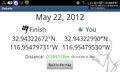
Geohash Droid screenshot at the hashpoint---details page @32.9432,-116.9548
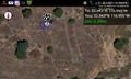
Geohash Droid screenshot at the hashpoint---satellite view @32.9432,-116.9548
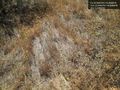
The hashpoint @32.9432,-116.9548


Achievements