Difference between revisions of "2012-05-26 32 -116"
From Geohashing
imported>LucasBrown ([live picture] A bag of chips placed on the hashpoint [http://www.openstreetmap.org/?lat=32.83021073&lon=-116.94364826&zoom=16&layers=B000FTF @32.8302,-116.9436]) |
imported>LucasBrown ([live picture] Geohash Droid details page screenshot at the hashpoint [http://www.openstreetmap.org/?lat=32.83021120&lon=-116.94364935&zoom=16&layers=B000FTF @32.8302,-116.9436]) |
||
| Line 31: | Line 31: | ||
Image:2012-05-26_32_-116_16-23-22-956.jpg | A bag of chips placed on the hashpoint [http://www.openstreetmap.org/?lat=32.83021073&lon=-116.94364826&zoom=16&layers=B000FTF @32.8302,-116.9436] | Image:2012-05-26_32_-116_16-23-22-956.jpg | A bag of chips placed on the hashpoint [http://www.openstreetmap.org/?lat=32.83021073&lon=-116.94364826&zoom=16&layers=B000FTF @32.8302,-116.9436] | ||
| + | |||
| + | Image:2012-05-26_32_-116_16-24-14-553.jpg | Geohash Droid details page screenshot at the hashpoint [http://www.openstreetmap.org/?lat=32.83021120&lon=-116.94364935&zoom=16&layers=B000FTF @32.8302,-116.9436] | ||
</gallery> | </gallery> | ||
Revision as of 23:24, 26 May 2012
| Sat 26 May 2012 in 32,-116: 32.8302435, -116.9436386 geohashing.info google osm bing/os kml crox |
Location
East of the end of the 52, in Santee, next to a water tank
Participants
JesseW 13:54, 25 May 2012 (EDT)
Plans
As it's Mouse Over Day, I plan to drive out there and be there at 4 PM; hopefully I can meet some other hashers. JesseW 13:54, 25 May 2012 (EDT)
Expedition
Tracklog
Photos
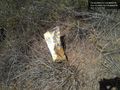
A bag of chips placed on the hashpoint @32.8302,-116.9436
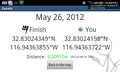
Geohash Droid details page screenshot at the hashpoint @32.8302,-116.9436


Achievements