Difference between revisions of "2012-05-26 32 -116"
From Geohashing
imported>LucasBrown ([live picture] Geohash Droid details page screenshot at the hashpoint [http://www.openstreetmap.org/?lat=32.83021120&lon=-116.94364935&zoom=16&layers=B000FTF @32.8302,-116.9436]) |
imported>LucasBrown (→Participants) |
||
| Line 14: | Line 14: | ||
<!-- who attended: If you link to your wiki user name in this section, your expedition will be picked up by the various statistics generated for geohashing. You may use three tildes ~ as a shortcut to automatically insert the user signature of the account you are editing with. | <!-- who attended: If you link to your wiki user name in this section, your expedition will be picked up by the various statistics generated for geohashing. You may use three tildes ~ as a shortcut to automatically insert the user signature of the account you are editing with. | ||
--> | --> | ||
| − | [[User:JesseW|JesseW]] 13:54, 25 May 2012 (EDT) | + | [[User:JesseW|JesseW]] 13:54, 25 May 2012 (EDT)<br> |
| + | [[User:LucasBrown|LucasBrown]] Reached the hashpoint at 16:15-ish, 2012-05-26 | ||
| + | |||
== Plans == | == Plans == | ||
<!-- what were the original plans --> | <!-- what were the original plans --> | ||
Revision as of 00:23, 27 May 2012
| Sat 26 May 2012 in 32,-116: 32.8302435, -116.9436386 geohashing.info google osm bing/os kml crox |
Location
East of the end of the 52, in Santee, next to a water tank
Participants
JesseW 13:54, 25 May 2012 (EDT)
LucasBrown Reached the hashpoint at 16:15-ish, 2012-05-26
Plans
As it's Mouse Over Day, I plan to drive out there and be there at 4 PM; hopefully I can meet some other hashers. JesseW 13:54, 25 May 2012 (EDT)
Expedition
Tracklog
Photos
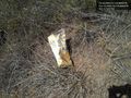
A bag of chips placed on the hashpoint @32.8302,-116.9436
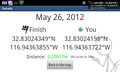
Geohash Droid details page screenshot at the hashpoint @32.8302,-116.9436


Achievements