Difference between revisions of "2012-05-26 47 -121"
imported>OtherJack (→Plans: MO day) |
m |
||
| (8 intermediate revisions by 2 users not shown) | |||
| Line 18: | Line 18: | ||
== Location == | == Location == | ||
| − | + | On someone's huge property in the hills south of Monroe. | |
== Participants == | == Participants == | ||
| Line 33: | Line 33: | ||
== Expedition == | == Expedition == | ||
| + | Well, I stayed out even later, and drank plenty, so I didn't end up leaving the house by bike until 1pm. Was glad that I did manage to get outside though - gorgeous day, mid 70s (low 20s C) and sunny, a little preview of Seattle summer. Cascade Mountains were very visible along large portions of the ride up the Burke-Gilman Trail and then across on Woodinville-Duvall Rd and up through the lower Snoqualmie valley. But I did not get up the steep climb to the hash subdivision until about 5pm. The plan was to catch the last bus from Monroe back to Everett at 5:56pm, so time was looking a little scarce, especially if there'd be a lot of bushwacking and/or owner permission needed. | ||
| − | + | I reached something that looked an awful lot like the Google street view of my turnoff, but it said 186th and Google said it should be at 191st, five "blocks" ahead. (In Washington they apparently insist on numbering little deadend roads way out in the country as if they're in the city.) I elected to trust the number and went ahead, only for the little road to turn to gravel (unfriendly to my road bike) and for there to be no sign of 191st anywhere. By the time I realized the google map label was simply wrong, another ten minutes were gone. But I went ahead east up the hill toward the hash, ditching my bike in a ditch when it got too steep and proceeding on foot. The country was very rugged and backwoodsy, it was a private gravel road shared by a few neighbors who were all hidden behind trees and overgrowth. Various engines were running somewhere. | |
| − | + | ||
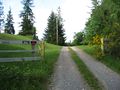
| + | But when I reached the hilltop, fully 0.4 mi (650 m) from the hashpoint according to the gps, the road was barred by an open gate with clear NO TRESPASSING signs. Beyond the gate the road curved away out of view, and I couldn't see houses or people. I expected the possibility of private property, but not someone who owns the entire square-mile surrounding the hashpoint! | ||
| + | |||
| + | I waited for a while to see if anyone would show up, but no one came. I thought about asking the neighbors who it was and if they were around, but the bus was coming soon and I didn't care to bike back, considering the late hour and my not being in shape, and having more physical work to do the next day. So that was it. | ||
| + | |||
| + | I did get to catch up with an old friend over tasty dinner and beer in Everett, at least. Took another bus back home afterward. | ||
== Photos == | == Photos == | ||
<gallery perrow="5"> | <gallery perrow="5"> | ||
| + | Image:2012-05-26 IMG 3089.JPG|Not much room for doubt here | ||
| + | Image:2012-05-26 IMG 3093.JPG|There was a sweet little snake right here, but it left while I was on the phone | ||
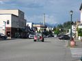
| + | Image:2012-05-26 IMG 3095.JPG|Back down toward civilization | ||
| + | Image:2012-05-26 IMG 3096.JPG|I passed the time waiting for the bus in Monroe... | ||
| + | Image:2012-05-26 IMG 3100.JPG|...admiring the Skykomish River... | ||
| + | Image:2012-05-26 IMG 3102.JPG|...and the Cascades beyond | ||
</gallery> | </gallery> | ||
| − | == | + | == Ribbons == |
| − | + | ||
<!-- Add any achievement ribbons you earned below, or remove this section --> | <!-- Add any achievement ribbons you earned below, or remove this section --> | ||
| + | {{Geohashing Day | ||
| + | |||
| + | | latitude = 47 | ||
| + | | longitude = -121 | ||
| + | | year = 2012 | ||
| + | | coorddate = 2012-05-26 | ||
| + | | mouseover = true | ||
| + | | name = [[User:OtherJack|OtherJack]] | ||
| + | | celebration = cycling into the east in glorious sunshine | ||
| + | | image = 2012-05-26 IMG 3100.JPG | ||
| + | |||
| + | }} | ||
| + | {{No trespassing | ||
| + | |||
| + | | latitude = 47 | ||
| + | | longitude = -121 | ||
| + | | date = 2012-05-26 | ||
| + | | name = [[User:OtherJack|OtherJack]] | ||
| + | | image = 2012-05-26 IMG 3089.JPG | ||
| + | |||
| + | }} | ||
| − | [[Category: | + | [[Category:Expeditions]] |
| + | [[Category:Expeditions with photos]] | ||
| + | [[Category:Coordinates not reached]] | ||
| + | [[Category:Not reached - No public access]] | ||
| + | {{location|US|WA|SN}} | ||
Latest revision as of 10:24, 16 March 2022
| Sat 26 May 2012 in 47,-121: 47.8302435, -121.9436386 geohashing.info google osm bing/os kml crox |
Location
On someone's huge property in the hills south of Monroe.
Participants
Plans
It's Mouseover Day... looks like some bushwhacking but doable. Land doesn't look developed on the satellite picture but there is a driveway-looking thing. Hard to tell whether there will be access.
Also I may stay out late tonight (Fri) and sleep in. But still hope to bike there and make it around 4pm!
--OtherJack 12:17, 25 May 2012 (EDT)
Expedition
Well, I stayed out even later, and drank plenty, so I didn't end up leaving the house by bike until 1pm. Was glad that I did manage to get outside though - gorgeous day, mid 70s (low 20s C) and sunny, a little preview of Seattle summer. Cascade Mountains were very visible along large portions of the ride up the Burke-Gilman Trail and then across on Woodinville-Duvall Rd and up through the lower Snoqualmie valley. But I did not get up the steep climb to the hash subdivision until about 5pm. The plan was to catch the last bus from Monroe back to Everett at 5:56pm, so time was looking a little scarce, especially if there'd be a lot of bushwacking and/or owner permission needed.
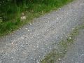
I reached something that looked an awful lot like the Google street view of my turnoff, but it said 186th and Google said it should be at 191st, five "blocks" ahead. (In Washington they apparently insist on numbering little deadend roads way out in the country as if they're in the city.) I elected to trust the number and went ahead, only for the little road to turn to gravel (unfriendly to my road bike) and for there to be no sign of 191st anywhere. By the time I realized the google map label was simply wrong, another ten minutes were gone. But I went ahead east up the hill toward the hash, ditching my bike in a ditch when it got too steep and proceeding on foot. The country was very rugged and backwoodsy, it was a private gravel road shared by a few neighbors who were all hidden behind trees and overgrowth. Various engines were running somewhere.
But when I reached the hilltop, fully 0.4 mi (650 m) from the hashpoint according to the gps, the road was barred by an open gate with clear NO TRESPASSING signs. Beyond the gate the road curved away out of view, and I couldn't see houses or people. I expected the possibility of private property, but not someone who owns the entire square-mile surrounding the hashpoint!
I waited for a while to see if anyone would show up, but no one came. I thought about asking the neighbors who it was and if they were around, but the bus was coming soon and I didn't care to bike back, considering the late hour and my not being in shape, and having more physical work to do the next day. So that was it.
I did get to catch up with an old friend over tasty dinner and beer in Everett, at least. Took another bus back home afterward.
Photos
Not much room for doubt here
There was a sweet little snake right here, but it left while I was on the phone
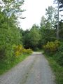
Back down toward civilization
I passed the time waiting for the bus in Monroe...
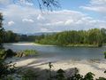
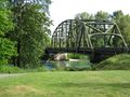
...admiring the Skykomish River...
...and the Cascades beyond


Ribbons
OtherJack earned the 2012 Mouse Over Day achievement
|
OtherJack earned the No trespassing consolation prize
|