Difference between revisions of "2012-06-09 -31 -64"
imported>Onicofago (→Plans) |
m (→Achievements) |
||
| (6 intermediate revisions by 3 users not shown) | |||
| Line 1: | Line 1: | ||
| − | |||
<!-- If you did not specify these parameters in the template, please substitute appropriate values for IMAGE, LAT, LON, and DATE (YYYY-MM-DD format) | <!-- If you did not specify these parameters in the template, please substitute appropriate values for IMAGE, LAT, LON, and DATE (YYYY-MM-DD format) | ||
| Line 23: | Line 22: | ||
<!-- who attended: If you link to your wiki user name in this section, your expedition will be picked up by the various statistics generated for geohashing. You may use three tildes ~ as a shortcut to automatically insert the user signature of the account you are editing with. | <!-- who attended: If you link to your wiki user name in this section, your expedition will be picked up by the various statistics generated for geohashing. You may use three tildes ~ as a shortcut to automatically insert the user signature of the account you are editing with. | ||
--> | --> | ||
| − | [[User:Onicofago|Onicofago]] and Significant Other | + | [[User:Onicofago|Onicofago]] and Significant Other. |
== Plans == | == Plans == | ||
| Line 30: | Line 29: | ||
== Expedition == | == Expedition == | ||
<!-- how it all turned out. your narrative goes here. --> | <!-- how it all turned out. your narrative goes here. --> | ||
| + | After being bored and watching TV in the afternoon, me and SO decided to go and try this geohashing thing for the first time. After a 45 minutes trip by car, and having my reliable and all worn-out and outdoorsy GPS loaded with the hash coordinates I was confident my first adventure would be successful. | ||
| − | + | We drank mate all the way, enjoying a very beautiful sunset in the Sierras of our Córdoba province. | |
| − | + | ||
| + | Thing is, we faced a Non Trespassing Sign in an urban area in Cosquín city... only 30 meters away from the geohash. So, better luck next time. Met three little kids playing with a dog, took a picture of the happy group. Dog's name was "Arturrro" according to one of the kids, which translates as "Arthurrrr". | ||
== Photos == | == Photos == | ||
| Line 39: | Line 40: | ||
--> | --> | ||
<gallery perrow="5"> | <gallery perrow="5"> | ||
| + | Image:2012-06-09_-31_-64_street.jpg | Street view | ||
| + | Image:2012-06-09_-31_-64_looksbad.jpg | Mmmmm... Not looking so good | ||
| + | Image:2012-06-09_-31_-64_notres.jpg | My very first No Trespassing sign | ||
| + | Image:2012-06-09_-31_-64_30m.jpg | Only 30m away!! | ||
| + | Image:2012-06-09_-31_-64_girlswitharthurr.jpg | Girls playing with Arthurrr The Dog | ||
</gallery> | </gallery> | ||
== Achievements == | == Achievements == | ||
{{#vardefine:ribbonwidth|800px}} | {{#vardefine:ribbonwidth|800px}} | ||
| − | + | {{No trespassing |latitude=-31 |longitude=-64 |date=2012-06-09 |name= [[User:Onicofago|Onicofago]]}} | |
| − | |||
| − | |||
| − | |||
| − | |||
| − | |||
| − | |||
| − | |||
| − | |||
| − | |||
| − | |||
[[Category:Expeditions]] | [[Category:Expeditions]] | ||
| − | |||
[[Category:Expeditions with photos]] | [[Category:Expeditions with photos]] | ||
| − | |||
| − | |||
| − | |||
| − | |||
| − | |||
| − | |||
| − | |||
| − | |||
| − | |||
[[Category:Coordinates not reached]] | [[Category:Coordinates not reached]] | ||
| − | |||
| − | |||
[[Category:Not reached - No public access]] when there is a man-made obstacle between you and the target | [[Category:Not reached - No public access]] when there is a man-made obstacle between you and the target | ||
| − | + | {{location|AR|X}} | |
| − | |||
| − | |||
Latest revision as of 21:57, 27 March 2020
| Sat 9 Jun 2012 in -31,-64: -31.2504609, -64.4625358 geohashing.info google osm bing/os kml crox |
Location
Urban area in Cosquín city, a very popular and touristic spot.
Participants
Onicofago and Significant Other.
Plans
The idea was to have a relaxed trip by car, enjoying some beautiful views, and then reach the geohash by foot before it was too dark. A very light bit of research in Google Maps was previously made.
Expedition
After being bored and watching TV in the afternoon, me and SO decided to go and try this geohashing thing for the first time. After a 45 minutes trip by car, and having my reliable and all worn-out and outdoorsy GPS loaded with the hash coordinates I was confident my first adventure would be successful.
We drank mate all the way, enjoying a very beautiful sunset in the Sierras of our Córdoba province.
Thing is, we faced a Non Trespassing Sign in an urban area in Cosquín city... only 30 meters away from the geohash. So, better luck next time. Met three little kids playing with a dog, took a picture of the happy group. Dog's name was "Arturrro" according to one of the kids, which translates as "Arthurrrr".
Photos
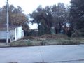
Street view
Mmmmm... Not looking so good
- Error creating thumbnail: Unable to save thumbnail to destination
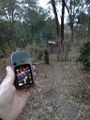
My very first No Trespassing sign
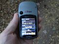
Only 30m away!!
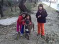
Girls playing with Arthurrr The Dog


Achievements
Onicofago earned the No trespassing consolation prize
|
when there is a man-made obstacle between you and the target