Difference between revisions of "2012-07-05 41 -87"
From Geohashing
imported>Haberdasher m (→Pictures) |
imported>Haberdasher m (→Pictures) |
||
| Line 31: | Line 31: | ||
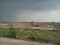
Image:2012-07-05_41_-88OHare.jpg | O'Hare-to-be continued | Image:2012-07-05_41_-88OHare.jpg | O'Hare-to-be continued | ||
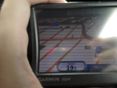
Image:2012-07-05_41_-87GPSProof.jpg | Coordinates reached! | Image:2012-07-05_41_-87GPSProof.jpg | Coordinates reached! | ||
| + | Image:2012-07-05_41_-87StupidGrin.jpg | Stupid Grin | ||
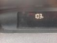
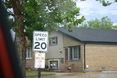
| + | Image:2012-07-05_41_-87SpeedLimit.jpg | Speed limit proof | ||
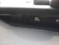
Image:2012-07-05_41_-87SpeedRacer.jpg | Speed Racer! | Image:2012-07-05_41_-87SpeedRacer.jpg | Speed Racer! | ||
Image:2012-07-05_41_-87Heat.jpg | It cooled down... | Image:2012-07-05_41_-87Heat.jpg | It cooled down... | ||
Revision as of 02:07, 6 July 2012
| Thu 5 Jul 2012 in Chicago: 41.9498582, -87.8739894 geohashing.info google osm bing/os kml crox |
Location
Today's location is on the side of the road in a residential neighborhood in Schiller Park.
Planning
Haberdasher is going to drive by in the afternoon, probably around 4 PM. -Haberdasher 15:55, 5 July 2012 (EDT)
Participants
Expedition
Pictures
Initial temperature
O'Hare's expansion-to-be
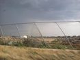
O'Hare-to-be continued
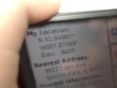
Coordinates reached!
- 2012-07-05 41 -87StupidGrin.jpg
Stupid Grin
Speed limit proof
Speed Racer!
It cooled down...


