Difference between revisions of "2012-07-06 40 -74"
From Geohashing
imported>Jevanyn (This house is as close as I'm going to get :-/ [http://www.openstreetmap.org/?lat=40.64230612&lon=-74.65646665&zoom=16&layers=B000FTF @40.6423,-74.6565]) |
m |
||
| (6 intermediate revisions by 2 users not shown) | |||
| Line 1: | Line 1: | ||
| − | |||
<!-- If you did not specify these parameters in the template, please substitute appropriate values for IMAGE, LAT, LON, and DATE (YYYY-MM-DD format) | <!-- If you did not specify these parameters in the template, please substitute appropriate values for IMAGE, LAT, LON, and DATE (YYYY-MM-DD format) | ||
| Line 23: | Line 22: | ||
<!-- who attended: If you link to your wiki user name in this section, your expedition will be picked up by the various statistics generated for geohashing. You may use three tildes ~ as a shortcut to automatically insert the user signature of the account you are editing with. | <!-- who attended: If you link to your wiki user name in this section, your expedition will be picked up by the various statistics generated for geohashing. You may use three tildes ~ as a shortcut to automatically insert the user signature of the account you are editing with. | ||
--> | --> | ||
| + | *[[User:Jevanyn|Jevanyn]] | ||
== Plans == | == Plans == | ||
| Line 34: | Line 34: | ||
== Photos == | == Photos == | ||
| + | I think this is all the photos, since I didn't get all the way there. These are just pictures from the journey. | ||
<!-- Insert pictures between the gallery tags using the following format: | <!-- Insert pictures between the gallery tags using the following format: | ||
Image:2010-##-## ## ## Alpha.jpg | Witty Comment | Image:2010-##-## ## ## Alpha.jpg | Witty Comment | ||
| Line 40: | Line 41: | ||
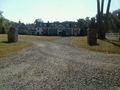
Image:2012-07-06_40_-74_16-19-12-932.jpg | This house is as close as I'm going to get :-/ [http://www.openstreetmap.org/?lat=40.64230612&lon=-74.65646665&zoom=16&layers=B000FTF @40.6423,-74.6565] | Image:2012-07-06_40_-74_16-19-12-932.jpg | This house is as close as I'm going to get :-/ [http://www.openstreetmap.org/?lat=40.64230612&lon=-74.65646665&zoom=16&layers=B000FTF @40.6423,-74.6565] | ||
| + | |||
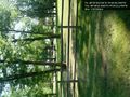
| + | Image:2012-07-06_40_-74_17-31-46-754.jpg | Large estate along the way | ||
| + | |||
| + | Image:2012-07-06_40_-74_17-32-26-723.jpg | Can you say "dilapidated"? I knew you could | ||
| + | |||
| + | Image:2012-07-06_40_-74_17-33-07-329.jpg | This road sign was too cool not to photograph | ||
| + | |||
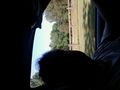
| + | Image:2012-07-06_40_-74_17-34-06-895.jpg | Silly grin minus flash = silhouette | ||
</gallery> | </gallery> | ||
| Line 49: | Line 58: | ||
<!-- =============== USEFUL CATEGORIES FOLLOW ================ | <!-- =============== USEFUL CATEGORIES FOLLOW ================ | ||
Delete the next line ONLY if you have chosen the appropriate categories below. If you are unsure, don't worry. People will read your report and help you with the classification. --> | Delete the next line ONLY if you have chosen the appropriate categories below. If you are unsure, don't worry. People will read your report and help you with the classification. --> | ||
| − | |||
| − | |||
| − | |||
| − | |||
| − | |||
| − | |||
| − | |||
| − | |||
[[Category:Expeditions]] | [[Category:Expeditions]] | ||
| − | |||
| − | |||
| − | |||
| − | |||
| − | |||
| − | |||
| − | |||
| − | |||
| − | |||
| − | |||
| − | |||
[[Category:Coordinates not reached]] | [[Category:Coordinates not reached]] | ||
| − | |||
| − | |||
| − | |||
| − | |||
[[Category:Not reached - No public access]] | [[Category:Not reached - No public access]] | ||
| − | + | [[Category:Not reached - Technology]] | |
| − | [[Category:Not reached - Technology]] | + | {{location|US|NJ|SO}} |
| − | |||
| − | |||
| − | |||
Latest revision as of 18:17, 18 March 2022
| Fri 6 Jul 2012 in 40,-74: 40.6551710, -74.6795101 geohashing.info google osm bing/os kml crox |
Location
Participants
Plans
Expedition
Tracklog
Photos
I think this is all the photos, since I didn't get all the way there. These are just pictures from the journey.
This house is as close as I'm going to get :-/ @40.6423,-74.6565
Large estate along the way
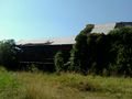
Can you say "dilapidated"? I knew you could
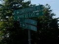
This road sign was too cool not to photograph
Silly grin minus flash = silhouette


