Difference between revisions of "2012-07-14 32 -116"
From Geohashing
imported>LucasBrown (Closest approach [http://www.openstreetmap.org/?lat=32.97691530&lon=-117.06222390&zoom=16&layers=B000FTF @32.9769,-117.0622]) |
imported>LucasBrown (Closest approach: the hasher was slightly off-screen to the upper left [http://www.openstreetmap.org/?lat=32.97691530&lon=-117.06222390&zoom=16&layers=B000FTF @32.9769,-117.0622]) |
||
| Line 42: | Line 42: | ||
Image:2012-07-14_32_-116_12-33-52-378.jpg | Closest approach [http://www.openstreetmap.org/?lat=32.97691530&lon=-117.06222390&zoom=16&layers=B000FTF @32.9769,-117.0622] | Image:2012-07-14_32_-116_12-33-52-378.jpg | Closest approach [http://www.openstreetmap.org/?lat=32.97691530&lon=-117.06222390&zoom=16&layers=B000FTF @32.9769,-117.0622] | ||
| + | |||
| + | Image:2012-07-14_32_-116_12-34-40-739.jpg | Closest approach: the hasher was slightly off-screen to the upper left [http://www.openstreetmap.org/?lat=32.97691530&lon=-117.06222390&zoom=16&layers=B000FTF @32.9769,-117.0622] | ||
</gallery> | </gallery> | ||
Revision as of 19:34, 14 July 2012
| Sat 14 Jul 2012 in 32,-116: 32.9940494, -116.7526735 geohashing.info google osm bing/os kml crox |
Location
Participants
Plans
Expedition
Tracklog
Photos
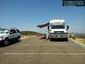
The authorities @32.9787,-117.0581
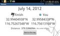
Closest approach @32.9769,-117.0622
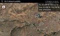
Closest approach: the hasher was slightly off-screen to the upper left @32.9769,-117.0622


Achievements