Difference between revisions of "2012-07-14 32 -116"
From Geohashing
imported>LucasBrown (The authorities [http://www.openstreetmap.org/?lat=32.97872790&lon=-117.05812670&zoom=16&layers=B000FTF @32.9787,-117.0581]) |
imported>FippeBot m (Location) |
||
| (6 intermediate revisions by one other user not shown) | |||
| Line 1: | Line 1: | ||
| − | |||
| − | |||
| − | |||
| − | |||
| − | |||
| − | |||
| − | |||
| − | |||
| − | |||
| − | |||
{{meetup graticule | {{meetup graticule | ||
| lat=32 | | lat=32 | ||
| Line 15: | Line 5: | ||
}} | }} | ||
| − | |||
__NOTOC__ | __NOTOC__ | ||
== Location == | == Location == | ||
| − | + | In the vicinity of Cedar Creek Falls, near the San Diego Country Estates (near Ramona) | |
== Participants == | == Participants == | ||
| − | + | [[User:LucasBrown|LucasBrown]] | |
| − | |||
| − | |||
| − | |||
| − | |||
== Expedition == | == Expedition == | ||
| − | + | Upon reaching the trail that led to the hashpoint, we found signs and sheriffs stating that there was no public access—people had died in the area of heatstroke and other hikers had taken to using the yards of the nearby homes as a bathroom. The closest approach was 380 meters. | |
| − | |||
| − | |||
| − | |||
== Photos == | == Photos == | ||
| − | |||
| − | |||
| − | |||
<gallery perrow="5"> | <gallery perrow="5"> | ||
Image:2012-07-14_32_-116_12-33-27-550.jpg | The authorities [http://www.openstreetmap.org/?lat=32.97872790&lon=-117.05812670&zoom=16&layers=B000FTF @32.9787,-117.0581] | Image:2012-07-14_32_-116_12-33-27-550.jpg | The authorities [http://www.openstreetmap.org/?lat=32.97872790&lon=-117.05812670&zoom=16&layers=B000FTF @32.9787,-117.0581] | ||
| + | |||
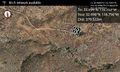
| + | Image:2012-07-14_32_-116_12-33-52-378.jpg | Closest approach [http://www.openstreetmap.org/?lat=32.97691530&lon=-117.06222390&zoom=16&layers=B000FTF @32.9769,-117.0622] | ||
| + | |||
| + | Image:2012-07-14_32_-116_12-34-40-739.jpg | Closest approach: the hasher was slightly off-screen to the upper left [http://www.openstreetmap.org/?lat=32.97691530&lon=-117.06222390&zoom=16&layers=B000FTF @32.9769,-117.0622] | ||
| + | |||
| + | Image:2012-07-14_32_-116_12-36-01-417.jpg | The hashpoint is over the knob. [http://www.openstreetmap.org/?lat=32.97775220&lon=-117.05230820&zoom=16&layers=B000FTF @32.9778,-117.0523] | ||
</gallery> | </gallery> | ||
== Achievements == | == Achievements == | ||
{{#vardefine:ribbonwidth|800px}} | {{#vardefine:ribbonwidth|800px}} | ||
| − | + | {{police geohash | latitude = 32 | longitude = -116 | date = 2012-07-14 | name = LucasBrown | anim = True}} | |
| − | |||
| − | |||
| − | |||
| − | |||
| − | |||
| − | |||
| − | |||
| − | |||
| − | |||
| − | |||
| − | |||
[[Category:Expeditions]] | [[Category:Expeditions]] | ||
| − | |||
[[Category:Expeditions with photos]] | [[Category:Expeditions with photos]] | ||
| − | |||
| − | |||
| − | |||
| − | |||
| − | |||
| − | |||
| − | |||
| − | |||
| − | |||
[[Category:Coordinates not reached]] | [[Category:Coordinates not reached]] | ||
| − | |||
| − | |||
| − | |||
| − | |||
| − | |||
[[Category:Not reached - No public access]] | [[Category:Not reached - No public access]] | ||
| − | + | {{location|US|CA|SD}} | |
| − | |||
| − | |||
| − | |||
| − | |||
| − | |||
| − | |||
| − | |||
Latest revision as of 05:01, 13 August 2019
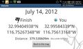
| Sat 14 Jul 2012 in 32,-116: 32.9940494, -116.7526735 geohashing.info google osm bing/os kml crox |
Location
In the vicinity of Cedar Creek Falls, near the San Diego Country Estates (near Ramona)
Participants
Expedition
Upon reaching the trail that led to the hashpoint, we found signs and sheriffs stating that there was no public access—people had died in the area of heatstroke and other hikers had taken to using the yards of the nearby homes as a bathroom. The closest approach was 380 meters.
Photos
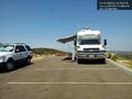
The authorities @32.9787,-117.0581
Closest approach @32.9769,-117.0622
Closest approach: the hasher was slightly off-screen to the upper left @32.9769,-117.0622
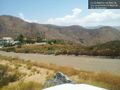
The hashpoint is over the knob. @32.9778,-117.0523


Achievements
LucasBrown earned the Police Geohash Achievement
|