Difference between revisions of "2012-07-16 33 -117"
From Geohashing
imported>LucasBrown ([live picture] Trail marker [http://www.openstreetmap.org/?lat=33.07590125&lon=-117.20884672&zoom=16&layers=B000FTF @33.0759,-117.2088]) |
imported>LucasBrown (→Photos) |
||
| Line 40: | Line 40: | ||
Image:2012-07-16_33_-117_09-36-34-404.jpg | First time making it to the geohash | Image:2012-07-16_33_-117_09-36-34-404.jpg | First time making it to the geohash | ||
| − | + | </gallery> | |
| + | Photos from LucasBrown's expedition: | ||
| + | <gallery perrow="5"> | ||
Image:2012-07-16_33_-117_13-08-45-661.jpg | Geohash Droid map at the hashpoint [http://www.openstreetmap.org/?lat=33.07655516&lon=-117.20846807&zoom=16&layers=B000FTF @33.0766,-117.2085] | Image:2012-07-16_33_-117_13-08-45-661.jpg | Geohash Droid map at the hashpoint [http://www.openstreetmap.org/?lat=33.07655516&lon=-117.20846807&zoom=16&layers=B000FTF @33.0766,-117.2085] | ||
Revision as of 21:18, 16 July 2012
| Mon 16 Jul 2012 in 33,-117: 33.0765388, -117.2084135 geohashing.info google osm bing/os kml crox |
Location
Participants
Plans
Expedition
Tracklog
Photos

First time making it to the geohash
Photos from LucasBrown's expedition:
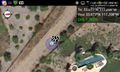
Geohash Droid map at the hashpoint @33.0766,-117.2085
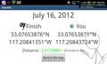
Geohash Droid details page at the hashpoint @33.0766,-117.2085
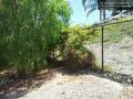
The hashpoint is just beyond the bush, within an arm's length of the fence @33.0765,-117.2085

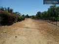
The trail from the road to the hashpoint @33.0765,-117.2085
The trail to the hashpoint @33.0762,-117.2088
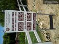
Trail sign @33.0761,-117.2090
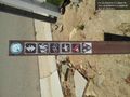
Trail marker @33.0759,-117.2088


Achievements