2012-08-06 52 -3
| Mon 6 Aug 2012 in 52,-3: 52.7405222, -3.9588775 geohashing.info google osm bing/os kml crox |
Location
While most of the Mid Wales graticule lies far, far away from anything, this particular hashpoint sits on a low hill right by the river Mawddach. Sure, the hill's forested and may not have any paths in it - but that's no problem, right?
Participants
- Huinesoron
- Huinesoron's mother
Preparation
From Saturday 4th through Friday 10th August, I was staying a short distance south of this hashpoint (my journey there allowed me to hit my first ever hash on the Saturday), right on the border between two virgin graticules, so I had a prime opportunity for geohashing. Unfortunately, Aberystwyth graticule is mostly underwater... and Wales is very bad for internet access... so I had a total of three possible hashes: Saturday, Sunday, and (because we're east of 30W) Monday. Saturday and Sunday were too far. Monday... was just right.
Oh, but no internet means no GPS even on a phone - so this was a map job. I pulled the map off the shelf and... cursed, because the map grid of course isn't aligned to the lat/long grid. Fortunately there were graticule intersections marked, but it was still a lot more maths than I'd been expecting - and the forest was so small! Surely there had to be a larger-scale map.
There was. That one didn't have graticule-intersection marks. Cue some overly-complicated ruler work (and more sums!) to pinpoint the hash (hey, it's been a decade since I last used a map this way, cut me some slack!). At least the second map showed some actual tracks... a tentative route was planned. Three routes, actually. Since the hashpoint itself was off-track, we could compass either from the end of a wall (blue option), a corner in the path (red), or along a contour (yellow).
But this is Geohashing. It was never going to be that simple...
Mapping photos
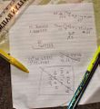
Sums hurt my head
But this hurts more than the sums
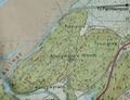
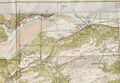
Where we're going
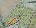
How we (might) get there


Expedition
We set off from our base of operations a couple of valleys south on a fine Welsh morning - that is to say, the coast was blue skies, a mile inland was under the Shadow of Mordor. Parking was easy at Penmaenpool (home of a toll bridge and a pub that doesn't serve chips - fries, if you're American), and we set off under... well, y'know, clouds.
After a stretch of very straight path, we came to our first utter departure from the plan: a gate at the wrong end of the hill. "Oh hey," I said, immediately christening it Hollin Gate, "this'll be quicker. Let's go in here!"
My mother foolishly agreed. Even more foolishly, she told the rest of our party to meet us in half an hour... I would have said two.
Still, the path up from Hollin was pretty; we kept rough track of where we were (sighting off the gap in the trees at Pant-y-cra, and the clusters of pines that mark the two highest summits), and soon managed to reach the peak of the lowest, northernmost hill. I started to think that 'half hour' wasn't such a wild overestimate after all.
Soon we came to the end of the obviously new path we were on; it was cut by an open, green track that looked significantly older. "Ah," I said, nodding wisely, "I know exactly where we are."
I said that quite a lot, as I recall.
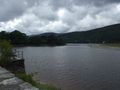
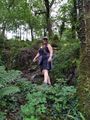
Afon Mawddach
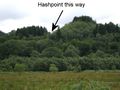
It's definitely in that insignificant dip
Can you tell this used to be a railway?
That's where we're going!
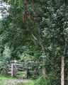
Because it's got a holly tree next to it, that's why
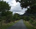
A very nice path that was not at all cursed


All Photos
(Collection of all the images featured in the above report)
Sums hurt my head
But this hurts more than the sums
Where we're going
How we (might) get there
Afon Mawddach
It's definitely in that insignificant dip
Can you tell this used to be a railway?
That's where we're going!
Because it's got a holly tree next to it, that's why
A very nice path that was not at all cursed
Achievements