Difference between revisions of "2012-08-19 54 -3"
imported>Alexandersmith |
imported>Alexandersmith |
||
| Line 2: | Line 2: | ||
Near Bouth, England. | Near Bouth, England. | ||
== Particpants == | == Particpants == | ||
| − | * Alexandersmith | + | * [[User:Alexandersmith|Alexandersmith]] |
== Plans == | == Plans == | ||
Bag a mountain bike ride in the early part of the day, visit the meet-up point on the way back home to Barrow-in-Furness. | Bag a mountain bike ride in the early part of the day, visit the meet-up point on the way back home to Barrow-in-Furness. | ||
| Line 23: | Line 23: | ||
There's no tracklog. I have a photo of my phone, with the Geohash app showing my location and the proximity to the geohash location. | There's no tracklog. I have a photo of my phone, with the Geohash app showing my location and the proximity to the geohash location. | ||
== Photos == | == Photos == | ||
| + | <gallery perrow="2"> | ||
| + | |||
| + | Image:20120819_132225a.jpg | Auto photo at the location | ||
| + | |||
| + | Image:20120819_Geohash_Achieved.JPG | Android Geohash app showing my location | ||
| + | |||
| + | </gallery> | ||
Revision as of 17:30, 19 August 2012
Location
Near Bouth, England.
Particpants
Plans
Bag a mountain bike ride in the early part of the day, visit the meet-up point on the way back home to Barrow-in-Furness. The meet-up point was very close to a narrow road, with a reasonable parking place opposite Bouth village hall.
Expedition
While I was a little bit excited on my first geo-hash, the mechanics were a bit dull.
At home, at the beginning of the day, I had checked the location of the geohash point, and sussed out that I could park within about 50 metres of it.
I put my Android phone in the 99pence dashboard holder, started the Geohash Droid app, and drove to the parking place I had chosen earlier.
The weather was drizzling with intermittent breaks of sun. Not enough to qualify for the drowned rat award. Before leaving the car, I took the precaution of putting my phone in a waterproof bag.
I went through the outer gate of the village hall, and scaled the fence behind it. Finding myself in a forest, I picked my way up a small hill while trying to keep my phone held upwards so the GPS receiver had a decent view of the sky. After a small amount of wandering around in decreasing circles, and watching the apparent GPS location wander about, I was able to get a stable reading of 1.53metres away from the official geohash.
Close enough, I shot two photos and left.
The geo-hash seemed to be on the border of a small forest, and someone's back garden. There was never any danger of it turning in to a No Tresspassing Geohash, as there seemed to be nobody about.
Tracklog
There's no tracklog. I have a photo of my phone, with the Geohash app showing my location and the proximity to the geohash location.
Photos

Auto photo at the location
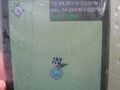
Android Geohash app showing my location

