Difference between revisions of "2012-08-25 46 -123"
imported>AeroIllini (It was a rather nice walk in the woods. [http://www.openstreetmap.org/?lat=.00000000&lon=.00000000&zoom=16&layers=B000FTF @.0000,.0000]) |
imported>AeroIllini |
||
| Line 1: | Line 1: | ||
| − | |||
<!-- If you did not specify these parameters in the template, please substitute appropriate values for IMAGE, LAT, LON, and DATE (YYYY-MM-DD format) | <!-- If you did not specify these parameters in the template, please substitute appropriate values for IMAGE, LAT, LON, and DATE (YYYY-MM-DD format) | ||
| Line 19: | Line 18: | ||
== Location == | == Location == | ||
<!-- where you've surveyed the hash to be --> | <!-- where you've surveyed the hash to be --> | ||
| + | Just off Route 6, southwest of Centralia, WA. | ||
== Participants == | == Participants == | ||
<!-- who attended: If you link to your wiki user name in this section, your expedition will be picked up by the various statistics generated for geohashing. You may use three tildes ~ as a shortcut to automatically insert the user signature of the account you are editing with. | <!-- who attended: If you link to your wiki user name in this section, your expedition will be picked up by the various statistics generated for geohashing. You may use three tildes ~ as a shortcut to automatically insert the user signature of the account you are editing with. | ||
--> | --> | ||
| + | [[User:AeroIllini|AeroIllini]] | ||
== Plans == | == Plans == | ||
<!-- what were the original plans --> | <!-- what were the original plans --> | ||
| + | The plan is to drive down to the point from Seattle in the morning, and then make a meetup in the [[Seattle]] graticule at 4 pm. | ||
== Expedition == | == Expedition == | ||
<!-- how it all turned out. your narrative goes here. --> | <!-- how it all turned out. your narrative goes here. --> | ||
| − | + | The drive down to Centralia was uneventful. I turned onto Route 6 and immediately went into a cell service black hole. Luckily I had remembered the name of the road to turn on, which turned out to be a gravel road about half an hour down Route 6. Once on the gravel, I relied on the distance calculation provided by the Android app. Unfortunately, I was thwarted twice... once by No Trespassing sign, and once by some extremely marshy land when I tried to go around. I was not prepared to ford any rivers, so I stopped as close as I could to the point, which was about 600 ft distant. I'm calling this one a failure, unless someone else wants to declare that I have the benefit of the doubt and 600 ft is "close enough." | |
| − | |||
| − | |||
== Photos == | == Photos == | ||
| Line 47: | Line 47: | ||
Image:2012-08-25_46_-123_14-26-51-428.jpg | Thwarted again! This marshy land was between me and the point. [http://www.openstreetmap.org/?lat=.00000000&lon=.00000000&zoom=16&layers=B000FTF @.0000,.0000] | Image:2012-08-25_46_-123_14-26-51-428.jpg | Thwarted again! This marshy land was between me and the point. [http://www.openstreetmap.org/?lat=.00000000&lon=.00000000&zoom=16&layers=B000FTF @.0000,.0000] | ||
| − | Image:2012-08-25_46_-123_14-28-35-354.jpg | The sleepy town of Pe Ell, WA. Probably named for Superman's great-uncle. [http://www.openstreetmap.org/?lat=.00000000&lon=.00000000&zoom=16&layers=B000FTF @.0000,.0000] | + | Image:2012-08-25_46_-123_14-28-35-354.jpg | The sleepy town of Pe Ell, WA, along Route 6. Probably named for Superman's great-uncle. [http://www.openstreetmap.org/?lat=.00000000&lon=.00000000&zoom=16&layers=B000FTF @.0000,.0000] |
Image:2012-08-25_46_-123_14-29-23-969.jpg | It was a rather nice walk in the woods. [http://www.openstreetmap.org/?lat=.00000000&lon=.00000000&zoom=16&layers=B000FTF @.0000,.0000] | Image:2012-08-25_46_-123_14-29-23-969.jpg | It was a rather nice walk in the woods. [http://www.openstreetmap.org/?lat=.00000000&lon=.00000000&zoom=16&layers=B000FTF @.0000,.0000] | ||
Revision as of 21:48, 25 August 2012
| Sat 25 Aug 2012 in 46,-123: 46.5604246, -123.3612976 geohashing.info google osm bing/os kml crox |
Location
Just off Route 6, southwest of Centralia, WA.
Participants
Plans
The plan is to drive down to the point from Seattle in the morning, and then make a meetup in the Seattle graticule at 4 pm.
Expedition
The drive down to Centralia was uneventful. I turned onto Route 6 and immediately went into a cell service black hole. Luckily I had remembered the name of the road to turn on, which turned out to be a gravel road about half an hour down Route 6. Once on the gravel, I relied on the distance calculation provided by the Android app. Unfortunately, I was thwarted twice... once by No Trespassing sign, and once by some extremely marshy land when I tried to go around. I was not prepared to ford any rivers, so I stopped as close as I could to the point, which was about 600 ft distant. I'm calling this one a failure, unless someone else wants to declare that I have the benefit of the doubt and 600 ft is "close enough."
Photos
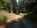
The road leading to the point. @46.5603,-123.3650

Me grinning, as close to the point as I could get. @.0000,.0000
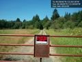
Thwarted! @46.5600,-123.3650
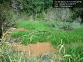
Thwarted again! This marshy land was between me and the point. @.0000,.0000
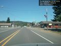
The sleepy town of Pe Ell, WA, along Route 6. Probably named for Superman's great-uncle. @.0000,.0000
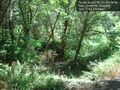
It was a rather nice walk in the woods. @.0000,.0000


Achievements