Difference between revisions of "2012-08-27 -35 149"
imported>1PE (→1PE) |
imported>FippeBot m (Location) |
||
| (2 intermediate revisions by one other user not shown) | |||
| Line 1: | Line 1: | ||
| − | |||
[[Image:{{{image|2012-08-28 -35 149 north.JPG}}}|thumb|left]] | [[Image:{{{image|2012-08-28 -35 149 north.JPG}}}|thumb|left]] | ||
| Line 38: | Line 37: | ||
== Photos == | == Photos == | ||
| − | |||
| − | |||
| − | |||
===[[User:1PE|1PE]]=== | ===[[User:1PE|1PE]]=== | ||
<gallery perrow="5"> | <gallery perrow="5"> | ||
| Line 54: | Line 50: | ||
[[Category:Expeditions]] | [[Category:Expeditions]] | ||
[[Category:Coordinates not reached]] | [[Category:Coordinates not reached]] | ||
| − | [[Category:Not reached - | + | [[Category:Not reached - Time constraints]] |
| − | |||
| − | |||
| − | |||
| − | |||
| − | |||
| − | |||
| − | |||
| − | |||
| − | |||
| − | |||
| − | |||
| − | |||
[[Category:Expeditions with photos]] | [[Category:Expeditions with photos]] | ||
| − | + | {{location|AU|ACT}} | |
| − | |||
| − | |||
| − | |||
| − | |||
| − | |||
| − | |||
| − | |||
| − | |||
| − | |||
| − | |||
| − | |||
| − | |||
| − | |||
| − | |||
| − | |||
| − | |||
| − | |||
| − | |||
| − | |||
| − | |||
| − | |||
Latest revision as of 05:50, 13 August 2019

| Mon 27 Aug 2012 in -35,149: -35.3073534, 149.2671187 geohashing.info google osm bing/os kml crox |
Location
This ON a fire trail / access road within the Kowen Forest pine plantation, Kowen ACT.
Participants
Plans
1PE
Go to the forest, drive the road, take pictures.
Expedition
1PE
Kowen Forest is an Australian Capital Territory Government-owned site where pine trees are grown for timber. (Kowen Forest – Area east of Canberra; 4671 hectares of plantation area; approximately 30 unplanted; age ranges between 2-34 yrs; shale based soils; rainfall 450mm/yr.) It is managed by ACT Parks Conservation and Lands.
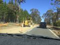
There is a series of well-formed gravel roads through the forest, giving access to the tree areas and also providing fire breaks.
I recalled trying to get into the Kowen Forest on another occasion, and remembered locked gates. I was also in the forest for a horse trial, when the gates were open.
Over lunchtime, I went to the southern gate, just north of the driver training facility on Sutton Road. The gate was locked and had signs proscribing entry by unauthorised motor vehicles and motorbikes. I then went to the northern entrance, Seven Mile Road, also off Sutton Road, thinking that this might be open. It had a similar gate and signage. I took pictures and left the ActiveGeohashing form beside the gate.
So, anyone wishing to walk or ride in on a mountain bike will be able to get there.
And, thanks for asking; my thumb is feeling much better, and will be right in about three weeks.
Tracklog
Photos
1PE
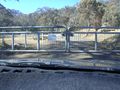
South entrance; a battering ram would be stopped dead in its tracks.
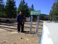
North entrance (Seven Mile Road); No way through, except on a mountain bike.
Held up both ways, but Sutton Road will be better afterwards!

