Difference between revisions of "2012-08-27 51 -1"
imported>DavidMiller m |
imported>DavidMiller m (→Achievements) |
||
| Line 71: | Line 71: | ||
=Achievements= | =Achievements= | ||
| + | |||
| + | {{land geohash | ||
| + | |||
| + | | latitude = 51 | ||
| + | | longitude = -1 | ||
| + | | date = 2012-08-27 | ||
| + | | name = DavidMiller Katie Wheatley Ryan Miller Chloé Miller | ||
| + | | image = Geohash-27-08-2012-51-1-DSC 12793.jpg | ||
| + | |||
| + | }} | ||
| + | |||
| + | {{Sunrise geohash | ||
| + | |||
| + | | latitude = 51 | ||
| + | | longitude = -1 | ||
| + | | date = 2012-08-27 | ||
| + | | name = DavidMiller Katie Wheatley Ryan Miller Chloé Miller | ||
| + | | image = Geohash-27-08-2012-51-1-DSC 12750.jpg | ||
| + | |||
| + | }} | ||
Revision as of 09:33, 27 August 2012
| Mon 27 Aug 2012 in Swindon: 51.3073534, -1.2671187 geohashing.info google osm bing/os kml crox |
Contents
Location
White Hill in Kingsclere just off of the b3051

Participants
- David Miller
- Ryan Miller
- Katie Wheatley
- Chloé Miller
Plans
David Miller's Plans
I will jump in the car with the family ( Katie, Ryan and Chloé ) and head to the hash point for around 11am.
- We ended up going at sunrise and beating the rain there! --DavidMiller 08:45, 27 August 2012 (GMT)
Reports
David Miller's Report
So we all got up at 4.20am. Tired as hell I had to have a coffee this morning! After everyone got dressed and got their stuff together, we headed to the car, at this point it's pitch black outside!
I set up the sat-nav to take us to the WhiteHill viewpoint. This was not an easy task and I had to scroll over a map, which looked very different from the one I was looking at on my phone. Once I found where it was that we needed to go we headed off.
Around 30 minutes later we arrived and gathered out bits. The sun is just starting to light up the sky. I checked the GPS on my phone and proceeded in the direction that I thought we had to go. It was a nice 15 - 20 minute walk later that we found ourselves at a gate that I had to climb over. I got over, the kids them climbed over, and then Kate was the only one left. Before she attempted to climb, I noticed that the gate had a latch, and it could be opened. It turned out that no climbing was needed after all!
We proceeded to walk a further 3 - 4 minutes and finally reached the hash point. I took some photos of the sunrise and of us. Unfortunately there was nothing around for us to make a marker to say we had been there. So we just headed on back to the car after around 15 minutes of photo taking.
When I have some free time, I intend to go back there and explore the area some more. It looks amazing and deserves a proper investigation.
Gallery
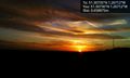
Sunrise is beautiful, isn't it? ( taken on my phone )
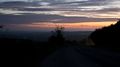
Just after we pulled up to the parking area near the hash point.
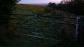
We almost got thwarted by this gate. Luckily we have climbing skills, after which, I realised that you could open it and walk thought!

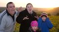
Group photo! ( taken on my phone )
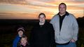
Group shot!

Another group shot, this time with the sun rise in the background. Shame we're not in focus though!

I do love a good sunrise!

Group shot with much better lighting.
Ryan was unhappy about his photo being taken.

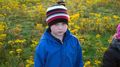
Chloé all cheerful on such a beautiful morning!

Cheese!

Cheese!
Silly faces!
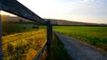
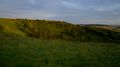
the Warren from up top.
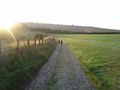
On our way back to the car. ( taken on my phone )

Getting ready to head back home.

I saw this snail and I just had to get a nice close up of it!

So mean!

We really must come here again some time. It looks like it really could be a lovely place for a walk.


Achievements
DavidMiller Katie Wheatley Ryan Miller Chloé Miller earned the Land geohash achievement
|
DavidMiller Katie Wheatley Ryan Miller Chloé Miller earned the Sunrise Geohash Achievement
|