Difference between revisions of "2012-08-28 28 -81"
imported>Justmatt (→Location) |
imported>Justmatt (→Plans) |
||
| Line 24: | Line 24: | ||
== Plans == | == Plans == | ||
<!-- what were the original plans --> | <!-- what were the original plans --> | ||
| + | Plans? Who makes plans? | ||
== Expedition == | == Expedition == | ||
Revision as of 01:04, 29 August 2012
| Tue 28 Aug 2012 in 28,-81: 28.6627753, -81.5923353 geohashing.info google osm bing/os kml crox |
Participants
Plans
Plans? Who makes plans?
Expedition
I just discovered hashing a few days ago, and after watching a couple locations be a couple miles out in the middle of a pasture, or in the middle of a lake, I saw this one. It looked like it'd be a good excuse to get back on my bike, so I threw it in the car and drove the 20 miles to Magnolia Park. It was a spur of the moment trip, and I didn't get to the park 'til about 1745. It was a little over 3.5 miles from where I parked to the CPA to the hash. Sadly, I couldn't actually reach the spot as it was about 85 feet off the path, on the other side of a canal and into the swamp, and my toes look like food to alligators. The attached picture is one of four gators I saw with certainty, and there were two or three more possibles, or quick divers.
I was about a mile and a half from getting back to my car when I rode into a downpour. From dry to soaked to the skin in about 3 seconds. So much for stopping for dinner on the way home!
I'll definitely be keeping an eye out for other out of the way locations like this as an excuse to get some more saddle time in.
Tracklog
Photos

First hash! 83 feet behind me, but alligators! @28.6627,-81.5926
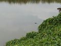
Alligators!


Achievements