Difference between revisions of "2012-08-31 48 -119"
imported>Thomcat ([live picture] Waiting for bridge construction [http://www.openstreetmap.org/?lat=48.62454950&lon=-118.11292793&zoom=16&layers=B000FTF @48.6245,-118.1129]) |
imported>FippeBot m (Location) |
||
| (One intermediate revision by one other user not shown) | |||
| Line 1: | Line 1: | ||
| − | |||
| − | |||
| − | |||
| − | |||
| − | |||
| − | |||
| − | |||
| − | |||
| − | |||
| − | |||
{{meetup graticule | {{meetup graticule | ||
| lat=48 | | lat=48 | ||
| Line 15: | Line 5: | ||
}} | }} | ||
| − | |||
__NOTOC__ | __NOTOC__ | ||
== Location == | == Location == | ||
| − | |||
Just off Soap Lake Road | Just off Soap Lake Road | ||
== Participants == | == Participants == | ||
| − | |||
| − | |||
* [[user:Thomcat|Thomcat]] | * [[user:Thomcat|Thomcat]] | ||
| − | == | + | == Expedition == |
| − | + | My family vacation was largely off-grid, and only twice could I check for geohashes. One of those times was Friday morning, however, so I looked into my route home and tried to find a good spot to visit. | |
| + | |||
| + | Just south of Omak, the satellite photo shows a more-or-less accessible geohash, just off something called Soap Lake Road. I bounced around the area in geohash droid so I could have some google maps available if there was no cell signal, then hit the road. Just after the first photo below, cell signal was lost, and not picked up again until approaching Wenatchee. | ||
| − | + | The geohash area was reached easily enough, and Soap Lake Road spotted. The family was amenable to a geohash visit... until they saw the condition of the road. Terrible! I gave it a valiant attempt, crawling the car up the road, but then discovered a few trailers at the top of the road. Squatters? Meth labs? Either way it was a bit scary, and the family was yelling at me to back up and get out of here. I snapped a quick picture of the locale and coordinates before I backed up slowly down the very bumpy road. | |
| − | |||
| − | + | Would I have tried it without the family? Would I have made it with Lilo on the dash? No way to know for sure. We then continued the drive home, a great vacation even without a geohash. Next time, Omak, I will conquer you! | |
| − | |||
== Photos == | == Photos == | ||
| − | |||
| − | |||
| − | |||
<gallery perrow="5"> | <gallery perrow="5"> | ||
Image:2012-08-31_48_-119_13-54-37-425.jpg | Waiting for bridge construction [http://www.openstreetmap.org/?lat=48.62454950&lon=-118.11292793&zoom=16&layers=B000FTF @48.6245,-118.1129] | Image:2012-08-31_48_-119_13-54-37-425.jpg | Waiting for bridge construction [http://www.openstreetmap.org/?lat=48.62454950&lon=-118.11292793&zoom=16&layers=B000FTF @48.6245,-118.1129] | ||
| + | Image:2012-08-31_48_-119_SoapLakeRoad.jpg | No Further Access | ||
</gallery> | </gallery> | ||
| − | |||
| − | |||
| − | |||
| − | |||
| − | |||
| − | |||
| − | |||
| − | |||
| − | |||
| − | |||
| − | |||
| − | |||
| − | |||
| − | |||
| − | |||
[[Category:Expeditions]] | [[Category:Expeditions]] | ||
| − | |||
[[Category:Expeditions with photos]] | [[Category:Expeditions with photos]] | ||
| − | |||
| − | |||
| − | |||
| − | |||
| − | |||
| − | |||
| − | |||
| − | |||
| − | |||
[[Category:Coordinates not reached]] | [[Category:Coordinates not reached]] | ||
| − | |||
| − | |||
| − | |||
| − | |||
| − | |||
[[Category:Not reached - No public access]] | [[Category:Not reached - No public access]] | ||
| − | + | {{location|US|WA|OK}} | |
| − | |||
| − | |||
| − | |||
| − | |||
| − | |||
| − | |||
| − | |||
Latest revision as of 05:09, 6 August 2019
| Fri 31 Aug 2012 in 48,-119: 48.2911124, -119.6668660 geohashing.info google osm bing/os kml crox |
Location
Just off Soap Lake Road
Participants
Expedition
My family vacation was largely off-grid, and only twice could I check for geohashes. One of those times was Friday morning, however, so I looked into my route home and tried to find a good spot to visit.
Just south of Omak, the satellite photo shows a more-or-less accessible geohash, just off something called Soap Lake Road. I bounced around the area in geohash droid so I could have some google maps available if there was no cell signal, then hit the road. Just after the first photo below, cell signal was lost, and not picked up again until approaching Wenatchee.
The geohash area was reached easily enough, and Soap Lake Road spotted. The family was amenable to a geohash visit... until they saw the condition of the road. Terrible! I gave it a valiant attempt, crawling the car up the road, but then discovered a few trailers at the top of the road. Squatters? Meth labs? Either way it was a bit scary, and the family was yelling at me to back up and get out of here. I snapped a quick picture of the locale and coordinates before I backed up slowly down the very bumpy road.
Would I have tried it without the family? Would I have made it with Lilo on the dash? No way to know for sure. We then continued the drive home, a great vacation even without a geohash. Next time, Omak, I will conquer you!
Photos
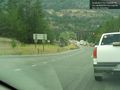
Waiting for bridge construction @48.6245,-118.1129
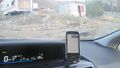
No Further Access

